Category:Old county maps of Kent
Jump to navigation
Jump to search
Ceremonial counties of England: Bedfordshire · Berkshire · Buckinghamshire · Cambridgeshire · Cheshire · Cornwall · Derbyshire · Devon · Dorset · Durham · East Riding of Yorkshire · Essex · Gloucestershire · Hampshire · Herefordshire · Hertfordshire · Kent · Lancashire · Leicestershire · Lincolnshire · Norfolk · Northamptonshire · Northumberland · Nottinghamshire · Oxfordshire · Rutland · Shropshire · Somerset · Staffordshire · Suffolk · Surrey · Warwickshire · Wiltshire · Worcestershire
City-counties:
Former historic counties: Cumberland · Huntingdonshire · Middlesex · North Riding of Yorkshire · Sussex · West Riding of Yorkshire · Westmorland · Yorkshire
Other former counties:
City-counties:
Former historic counties: Cumberland · Huntingdonshire · Middlesex · North Riding of Yorkshire · Sussex · West Riding of Yorkshire · Westmorland · Yorkshire
Other former counties:
Media in category "Old county maps of Kent"
The following 15 files are in this category, out of 15 total.
-

-
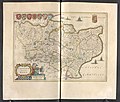
 Atlas Van der Hagen-KW1049B11 014-CANTIUM Vernacule KENT.jpeg 5,500 × 4,304; 3.89 MB
-
 "Cantium vernacule Kent" (22252418815).jpg 4,159 × 3,056; 2.53 MB
-
-
 Maps of England circa 1670, Kent 20 of 40 (13433110903).jpg 6,333 × 4,983; 4.21 MB
-
 Aikin(1800) p329 - Kent.jpg 1,952 × 1,070; 393 KB
-
 Gray1824.kent.jpg 793 × 974; 154 KB
-
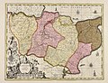
 Carte du comté de Kent-Mc Corquodale-1.jpg 3,228 × 2,076; 3.08 MB
-

-

-
 BOSWORTH(1898) p56 - Geological Map of Kent.jpg 1,920 × 1,170; 783 KB
-
 BOSWORTH(1898) p75 - Kent.jpg 1,920 × 1,170; 550 KB
-
 Cantium vernacule Kent - CBT 6599272.jpg 5,440 × 4,174; 6.86 MB
-
 CAPPER(1825) p01.523 - Kent.jpg 2,375 × 1,360; 1.01 MB
-
 Ogilby Kent.jpg 1,404 × 1,080; 789 KB


.jpg)
.5.(14).jpg)
.jpg)
_p329_-_Kent.jpg)


.jpg)
.jpg)
_p56_-_Geological_Map_of_Kent.jpg)
_p75_-_Kent.jpg)

_p01.523_-_Kent.jpg)
