Category:Images by Jim Barton
Jump to navigation
Jump to search

Media in category "Images by Jim Barton"
The following 200 files are in this category, out of 1,770 total.
(previous page) (next page)-
 'Dead Wife' gatepost - geograph.org.uk - 1392568.jpg 640 × 424; 102 KB
-
-
-

-

-
 392m top on ridge to Patie's Hill - geograph.org.uk - 1177972.jpg 640 × 480; 94 KB
-
 A bend in the River Tweed - geograph.org.uk - 1538286.jpg 640 × 424; 165 KB
-
 A cascade on the Allt Abhagaith - geograph.org.uk - 1575131.jpg 640 × 424; 176 KB
-
 A fall on the Black Water, Little Garve - geograph.org.uk - 1575176.jpg 640 × 424; 149 KB
-
 A fine clump of cotton grass - geograph.org.uk - 875161.jpg 640 × 480; 114 KB
-
 A frozen Bowscale Tarn - geograph.org.uk - 1749220.jpg 800 × 530; 215 KB
-
 A frozen Loch Etchachan - geograph.org.uk - 1717586.jpg 800 × 532; 103 KB
-
-
 A narrow stretch of Glen Feshie - geograph.org.uk - 1564745.jpg 640 × 424; 62 KB
-
 A patchwork of fields in the Wye Valley - geograph.org.uk - 1502742.jpg 640 × 424; 125 KB
-
 A patchwork of pastel colours on Newby Kipps - geograph.org.uk - 1722169.jpg 1,600 × 1,061; 581 KB
-
 A plantation in The Glen - geograph.org.uk - 1691370.jpg 800 × 530; 219 KB
-
 A power station and its waste ash - geograph.org.uk - 1569105.jpg 640 × 424; 49 KB
-
 A pub sign that rhymes, Clun - geograph.org.uk - 1502929.jpg 640 × 424; 55 KB
-
 A quieter stretch of the Black Water - geograph.org.uk - 1575383.jpg 640 × 424; 178 KB
-
 A rock outcrop on the River North Esk - geograph.org.uk - 1589884.jpg 640 × 424; 164 KB
-
 A rough shelter - geograph.org.uk - 1253070.jpg 640 × 424; 108 KB
-
 A Scots pine by the River Feshie - geograph.org.uk - 1564581.jpg 640 × 424; 99 KB
-

-
 A tranquil day at Gladhouse Reservoir - geograph.org.uk - 1713019.jpg 800 × 530; 137 KB
-
 A variety of road signs, Kirkton - geograph.org.uk - 1540841.jpg 640 × 424; 117 KB
-
 A view back down Kirkton Glen - geograph.org.uk - 1432935.jpg 640 × 424; 130 KB
-
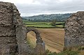 A view up the valley from Clun Castle - geograph.org.uk - 1502911.jpg 640 × 424; 103 KB
-

-
 A welcome sign near Broughton - geograph.org.uk - 1714605.jpg 1,024 × 679; 353 KB
-
 A winter day at Megget Reservoir - geograph.org.uk - 1615425.jpg 640 × 424; 98 KB
-
-
 A winter view of Cademuir - geograph.org.uk - 1656928.jpg 640 × 424; 65 KB
-
-
 A1 viaduct across the Tyne - geograph.org.uk - 1354683.jpg 640 × 480; 64 KB
-

-
 A68 road bridge over the River Esk - geograph.org.uk - 1589918.jpg 640 × 424; 92 KB
-
 A701 from Annanhead Hill - geograph.org.uk - 1737133.jpg 800 × 530; 212 KB
-
 Above Damhead Wood - geograph.org.uk - 1291905.jpg 640 × 424; 73 KB
-

-
 Afternoon sun in the Newlands Valley - geograph.org.uk - 1750853.jpg 1,024 × 679; 258 KB
-

-
-
 Allt a Mharcaidh - geograph.org.uk - 1774938.jpg 800 × 530; 236 KB
-
 Allt a' Chalda Mor and lochan - geograph.org.uk - 1253357.jpg 640 × 424; 90 KB
-

-
 Allt Bad an t-Seabhaig - geograph.org.uk - 1251852.jpg 640 × 480; 91 KB
-

-
 Allt Coire Ghaidheil - geograph.org.uk - 1319150.jpg 424 × 640; 101 KB
-
 Allt Coulavie above the Sputan Ban falls - geograph.org.uk - 976101.jpg 640 × 480; 125 KB
-
 Allt Grannda waterfall - geograph.org.uk - 1765376.jpg 533 × 800; 173 KB
-
 Allt Mor - geograph.org.uk - 1454642.jpg 640 × 424; 134 KB
-
 Allt Scheicheachan bothy in 1978 - geograph.org.uk - 1765941.jpg 800 × 533; 70 KB
-
 Allt Tarsuinn - geograph.org.uk - 1253100.jpg 640 × 424; 105 KB
-
 Almshouses, Hay-on-Wye - geograph.org.uk - 1502787.jpg 640 × 424; 93 KB
-
 An arch of the Tweed Bridge, Peebles - geograph.org.uk - 1632524.jpg 640 × 424; 102 KB
-
-
 Ancient and modern - geograph.org.uk - 892223.jpg 640 × 480; 68 KB
-
 Ancient settlement site on Cademuir - geograph.org.uk - 1703346.jpg 640 × 424; 105 KB
-
 Ancient settlement site, Manor Valley - geograph.org.uk - 1741666.jpg 800 × 530; 236 KB
-
 Annandale from Great Hill - geograph.org.uk - 1737505.jpg 1,024 × 679; 297 KB
-
 Another 2 years' worth of erosion - geograph.org.uk - 1320088.jpg 640 × 424; 107 KB
-
 Aonach Beag and Beinn Eibhinn - geograph.org.uk - 1719545.jpg 800 × 533; 74 KB
-
 Approaching Cardrona Village - geograph.org.uk - 1639153.jpg 640 × 424; 65 KB
-
 Approaching Glen Tilt - geograph.org.uk - 1725800.jpg 1,024 × 683; 121 KB
-
 Approaching Mungrisdale from the north - geograph.org.uk - 1749294.jpg 800 × 530; 149 KB
-
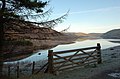
 Approaching Portmore Reservoir - geograph.org.uk - 1426337.jpg 640 × 480; 74 KB
-
 Approaching site of former Maxton station (geograph 3902855).jpg 1,024 × 678; 234 KB
-

-
 Arched passageway, Drochil Castle (1) - geograph.org.uk - 1703470.jpg 530 × 800; 154 KB
-
 Arched passageway, Drochil Castle (2) - geograph.org.uk - 1703483.jpg 800 × 530; 178 KB
-
 Arm of Megget Reservoir - geograph.org.uk - 1230741.jpg 640 × 480; 78 KB
-
 Ash lagoon with bird life - geograph.org.uk - 1569102.jpg 640 × 408; 67 KB
-
 Askival from Hallival - geograph.org.uk - 1759091.jpg 800 × 533; 75 KB
-
 Askival N ridge - geograph.org.uk - 1759108.jpg 533 × 800; 75 KB
-
 Askival summit - geograph.org.uk - 1759133.jpg 800 × 533; 57 KB
-
-
 At the Bealach Coire Ghaidheil - geograph.org.uk - 1319290.jpg 640 × 424; 113 KB
-
 Auchendinny station - Geograph-2732561-by-Jim-Barton.jpg 800 × 530; 279 KB
-

-
-
-
 Back Burn - geograph.org.uk - 1371972.jpg 640 × 480; 92 KB
-
 Back Burn below Crumley Hill - geograph.org.uk - 1615468.jpg 640 × 424; 142 KB
-
 Back down to valley level - geograph.org.uk - 994673.jpg 640 × 480; 130 KB
-
 Back to work - geograph.org.uk - 916152.jpg 640 × 480; 117 KB
-
 Band of crags, Beinn Udlaidh - geograph.org.uk - 1301876.jpg 640 × 480; 97 KB
-
 Bannerdale Crags and East Ridge - geograph.org.uk - 1749118.jpg 800 × 530; 177 KB
-
 Bannerdale Crags from the NW - geograph.org.uk - 1749175.jpg 800 × 530; 193 KB
-
 Barns House - geograph.org.uk - 1540793.jpg 640 × 424; 114 KB
-
 Bass Rock and Tyninghame woods - geograph.org.uk - 1603133.jpg 640 × 424; 48 KB
-
 Be careful^ - geograph.org.uk - 979497.jpg 640 × 480; 88 KB
-

-
 Bealach na h-Uidhe - geograph.org.uk - 1253305.jpg 640 × 424; 104 KB
-
 Bearnais Bothy in 1978 - geograph.org.uk - 1766831.jpg 800 × 533; 100 KB
-
 Bedford Memorial Bridge, Tarf Water - geograph.org.uk - 1725832.jpg 1,024 × 683; 135 KB
-
 Before and after felling - geograph.org.uk - 1283794.jpg 640 × 424; 126 KB
-
 Beinn na Stac from Glen Dibidil - geograph.org.uk - 1759313.jpg 800 × 533; 79 KB
-
-
 Bellanrig in winter - geograph.org.uk - 1656840.jpg 640 × 424; 71 KB
-

-
 Ben Alder cliffs and cornice - geograph.org.uk - 1711478.jpg 640 × 423; 43 KB
-
 Ben Alder from Allt a' Chaol-reidhe - geograph.org.uk - 1711437.jpg 640 × 425; 59 KB
-
 Ben Alder from Aonach Beag - geograph.org.uk - 1719588.jpg 800 × 533; 76 KB
-
 Ben Alder summit plateau - geograph.org.uk - 1711486.jpg 640 × 425; 50 KB
-
 Beneath the Forth Bridge - geograph.org.uk - 1332395.jpg 640 × 424; 118 KB
-
 Between Huntly Cot and Mauldslie - geograph.org.uk - 1712957.jpg 800 × 530; 138 KB
-
 Big boulders below Creag nan Cuaran - geograph.org.uk - 1301858.jpg 640 × 480; 110 KB
-
 Biggar Gasworks Museum - geograph.org.uk - 1395352.jpg 640 × 480; 75 KB
-
 Biggar Water joins the Tweed - geograph.org.uk - 1714766.jpg 1,600 × 1,061; 646 KB
-

-
 Birnock Water from Greygill Head - geograph.org.uk - 1379205.jpg 640 × 480; 74 KB
-
 Bitch Cleuch and Manor valley - geograph.org.uk - 994607.jpg 640 × 480; 127 KB
-
 Black Law summit trig point - geograph.org.uk - 1033631.jpg 640 × 480; 88 KB
-
 Black Sike - geograph.org.uk - 1291763.jpg 640 × 424; 129 KB
-
 Blea Beck, Shap Wells - geograph.org.uk - 1531328.jpg 640 × 424; 192 KB
-
 Blencathra from Troutbeck - geograph.org.uk - 1749462.jpg 800 × 530; 165 KB
-
 Bloodhope Burn - geograph.org.uk - 1425084.jpg 640 × 424; 121 KB
-
-
 Blue plaque for a Nobel prize winner - geograph.org.uk - 903255.jpg 640 × 480; 110 KB
-
 Boathouse, Loch Eddy - geograph.org.uk - 889946.jpg 640 × 424; 121 KB
-
 Bodesbeck Track crosses the ridge fence - geograph.org.uk - 1326707.jpg 640 × 480; 109 KB
-
 Bog and heather moor - geograph.org.uk - 1596582.jpg 640 × 424; 80 KB
-
 Bog woodland, Allt a Mharcaidh - geograph.org.uk - 1776238.jpg 800 × 530; 169 KB
-
 Boggy ground and boulder field - geograph.org.uk - 1510755.jpg 640 × 424; 106 KB
-
 Boggy path - geograph.org.uk - 1456291.jpg 640 × 424; 113 KB
-
 Bonar Bridge - geograph.org.uk - 1455794.jpg 640 × 424; 98 KB
-
 Bonnington Iron Bridge, Falls of Clyde - geograph.org.uk - 862375.jpg 640 × 480; 162 KB
-
 Borders Wood pasture planting - geograph.org.uk - 1291805.jpg 640 × 424; 97 KB
-
 Boulders in the Black Water - geograph.org.uk - 1575168.jpg 640 × 424; 158 KB
-
-
 Boxing Day near Bonnington - geograph.org.uk - 1633461.jpg 640 × 424; 77 KB
-
 Bracken on the hillside - geograph.org.uk - 1379116.jpg 640 × 480; 109 KB
-
 Braeruthven ruin above Kingussie - geograph.org.uk - 1777208.jpg 800 × 530; 165 KB
-
 Braided channels in the Manor Water - geograph.org.uk - 1740877.jpg 800 × 530; 129 KB
-
 Braithwaite from above - geograph.org.uk - 1749502.jpg 1,024 × 679; 358 KB
-
 Bridge and platform, former Rosslyn Castle Station (geograph 6088962).jpg 1,600 × 999; 615 KB
-
 Bridge at Haystoun Estate - geograph.org.uk - 1007308.jpg 640 × 424; 133 KB
-
 Bridge over Allt Ceann Loch Luichart - geograph.org.uk - 1365742.jpg 640 × 424; 125 KB
-
 Bridge over Allt Coire Follais - geograph.org.uk - 1774872.jpg 800 × 530; 228 KB
-
 Bridge over Allt Garbh - geograph.org.uk - 976049.jpg 640 × 480; 117 KB
-
 Bridge over Boredale Beck - geograph.org.uk - 1171960.jpg 640 × 480; 143 KB
-
 Bridge over Garbh Uisge - geograph.org.uk - 1319035.jpg 640 × 424; 97 KB
-
 Bridge over Longlands Beck - geograph.org.uk - 1752172.jpg 800 × 530; 218 KB
-
 Bridge over Peebles - Broughton railway - geograph.org.uk - 1612016.jpg 640 × 424; 124 KB
-
 Bridge over the Fairliehope Burn - geograph.org.uk - 1178008.jpg 640 × 480; 102 KB
-
 Bridge over the Walker Burn - geograph.org.uk - 1338148.jpg 640 × 424; 114 KB
-
 Bridge over the Wirral Way path - geograph.org.uk - 1737049.jpg 800 × 530; 221 KB
-
 Bridge over West Water - geograph.org.uk - 1761177.jpg 800 × 530; 189 KB
-

-
 Bridleway above Garreg-ddu Reservoir - geograph.org.uk - 1501923.jpg 640 × 424; 141 KB
-
 Brocken spectre, Beinn na Cille - geograph.org.uk - 1779469.jpg 800 × 533; 64 KB
-
 Brockhope Rig - geograph.org.uk - 1326511.jpg 640 × 480; 97 KB
-
 Broken Cleuch and Moffat Water - geograph.org.uk - 1326593.jpg 640 × 480; 112 KB
-
 Broom Hill from Stob Law - geograph.org.uk - 1371985.jpg 640 × 480; 65 KB
-
 Broughton from Helm End - geograph.org.uk - 1714265.jpg 1,024 × 679; 190 KB
-
 Building work at Cardrona (2) (geograph 6031303).jpg 1,600 × 1,060; 380 KB
-
 Building work at Cardrona (4) (geograph 6151825).jpg 1,600 × 1,060; 376 KB
-
 Building work at Cardrona (geograph 5916920).jpg 1,600 × 1,060; 360 KB
-
 Buildings at Martindale - geograph.org.uk - 1171959.jpg 640 × 480; 108 KB
-

-
 Burn and forestry edge - geograph.org.uk - 1251777.jpg 640 × 480; 114 KB
-
 Burn and rough ground - geograph.org.uk - 901109.jpg 640 × 480; 119 KB
-

-
 Burn draining from Sgoran Dubh Beag - geograph.org.uk - 1775733.jpg 800 × 530; 166 KB
-
 Burn from Loch an Claonaite - geograph.org.uk - 1252773.jpg 640 × 480; 120 KB
-
 Burn on west side of Kailzie Hill - geograph.org.uk - 1534758.jpg 640 × 424; 128 KB
-
 Burn west of Creag Ghlas - geograph.org.uk - 942553.jpg 640 × 480; 114 KB
-
 Burn, Shielhope Hill - geograph.org.uk - 1543894.jpg 640 × 424; 127 KB
-
 Butter Knowe and Black Hill - geograph.org.uk - 1395258.jpg 640 × 480; 71 KB
-
 Bynack Lodge in snow - geograph.org.uk - 1725746.jpg 1,024 × 683; 94 KB
-
 Cademuir col under snow - geograph.org.uk - 1656864.jpg 640 × 424; 70 KB
-
 Cademuir forest road under snow - geograph.org.uk - 1653290.jpg 640 × 424; 126 KB
-
 Cademuir Forest under snow - geograph.org.uk - 1633428.jpg 640 × 424; 141 KB
-
 Cafe at the RSPB Reserve, Conwy - geograph.org.uk - 1093290.jpg 640 × 424; 72 KB
-
 Cairn about 450m, Greygill Head - geograph.org.uk - 1379182.jpg 640 × 480; 64 KB
-
-
 Cairn approx. 350m, Greygill Head - geograph.org.uk - 1379133.jpg 640 × 480; 80 KB
-
 Cairn at 367m - geograph.org.uk - 1226266.jpg 640 × 480; 107 KB
-
 Cairn at Hare Law hill fort - geograph.org.uk - 1274433.jpg 640 × 424; 94 KB
-
 Cairn at path junction - geograph.org.uk - 1365250.jpg 640 × 424; 115 KB
-
 Cairn at point 291 m Manor Hill - geograph.org.uk - 1757943.jpg 800 × 530; 222 KB
-
 Cairn at point 482m - geograph.org.uk - 1501957.jpg 640 × 424; 108 KB
-

-
 Cairn marking the pass in Trusmadoor - geograph.org.uk - 1753278.jpg 800 × 530; 210 KB
-
 Cairn NE of Cnoc na Creige - geograph.org.uk - 1254247.jpg 640 × 480; 105 KB
-
 Cairn near 400m, Greygill Head - geograph.org.uk - 1379158.jpg 640 × 480; 82 KB
-
 Cairn on Cauldstane Rig - geograph.org.uk - 1230699.jpg 640 × 480; 92 KB
-
 Cairn on Gool Knowe - geograph.org.uk - 1543915.jpg 640 × 424; 104 KB
-
 Cairn on Hamilton Hill, Peebles - geograph.org.uk - 1602325.jpg 640 × 424; 85 KB
-
 Cairn on Juniper Craigs - geograph.org.uk - 1722151.jpg 1,600 × 1,061; 666 KB
-
 Cairn on Mid Hill - geograph.org.uk - 1066178.jpg 640 × 480; 113 KB
-
 Cairn on Mid Rig - geograph.org.uk - 1326540.jpg 640 × 480; 85 KB
-
 Cairn on Mid Rig - geograph.org.uk - 1326654.jpg 640 × 480; 65 KB
-
 Cairn on Talla East Side - geograph.org.uk - 1615607.jpg 640 × 424; 97 KB
-
 Cairn on White Craig Hill - geograph.org.uk - 1209206.jpg 640 × 480; 97 KB
-
 Cairn on White Knott - geograph.org.uk - 1171671.jpg 640 × 480; 89 KB
-
 Cairn on Whitelaw Hill - geograph.org.uk - 1392528.jpg 640 × 424; 102 KB
-
 Cairn, Glenrath Hill - geograph.org.uk - 1371999.jpg 640 × 480; 75 KB
-
 Cairn, Pikes Knowe - geograph.org.uk - 1227466.jpg 640 × 480; 72 KB


.jpg)

_-_geograph.org.uk_-_1703470.jpg)
_-_geograph.org.uk_-_1703483.jpg)


.jpg)


_(geograph_6031303).jpg)
_(geograph_6151825).jpg)
.jpg)


