Category:Princess Elizabeth Land
Jump to navigation
Jump to search
sector of the Australian Antarctic Territory  | |||||
| Upload media | |||||
| Instance of | |||||
|---|---|---|---|---|---|
| Part of |
| ||||
| Named after | |||||
| Location |
| ||||
| Located in or next to body of water | |||||
| Different from | |||||
 | |||||
Subcategories
This category has the following 3 subcategories, out of 3 total.
Media in category "Princess Elizabeth Land"
The following 8 files are in this category, out of 8 total.
-
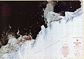 Amanda Bay Satellite Image Map.jpg 11,811 × 8,264; 39.9 MB
-
 Mawson Escarpment North, Mac.Robertson Land, Ostantarktika.jpg 1,181 × 827; 1.11 MB
-
 Mawson Escarpment South, Mac.Robertson Land, Ostantarktika.jpg 1,902 × 1,014; 413 KB
-
 NASA Landsat SorsdalGlacier Bands432.jpg 678 × 500; 160 KB
-
 Northern tip of Mount Brown, East Antarctica.jpg 3,264 × 2,448; 2.35 MB
-
 Prince Charles Mountains, Lambert-Gletscher und Amery-Schelfeis, Ostantarktika.png 3,306 × 2,339; 228 KB
-
 Princess Elizabeth Land in Australian Antarctic Territory.svg 1,200 × 1,200; 1.02 MB
-
 Princess Elizabeth Land stub map.png 275 × 334; 21 KB


