Category:Old maps of Lake Ontario
Jump to navigation
Jump to search
Subcategories
This category has only the following subcategory.
C
Media in category "Old maps of Lake Ontario"
The following 59 files are in this category, out of 59 total.
-

-

-
-

-
 Annual report of the Regents - New York State Museum. (1902) (19178591880).jpg 3,144 × 2,180; 1.3 MB
-

-
-

-

-
 Annual report of the Regents - New York State Museum. (1908) (18743935884).jpg 3,189 × 2,280; 896 KB
-
 Annual report of the Regents - New York State Museum. (1908) (18745844623).jpg 3,172 × 2,254; 912 KB
-
 Annual report of the Regents - New York State Museum. (1908) (18745848703).jpg 3,163 × 2,238; 896 KB
-
 Annual report of the Regents - New York State Museum. (1908) (19180315509).jpg 3,163 × 2,254; 939 KB
-
 Annual report of the Regents - New York State Museum. (1908) (19360374292).jpg 3,054 × 2,168; 1.45 MB
-
 Annual report of the Regents - New York State Museum. (1908) (19366488305).jpg 3,146 × 2,238; 893 KB
-
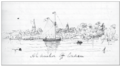 At anchor off Consecon.png 430 × 239; 139 KB
-
 Chart of Lake Ontario (NYPL b19531878-5376740).jpg 7,323 × 8,874; 58.27 MB
-
 Chart of Lake Ontario (NYPL b19531878-5376740).tiff 7,760 × 10,328, 2 pages; 229.57 MB
-
 Chart of Lake Ontario (NYPL b19531878-5376741).jpg 7,604 × 8,899; 61.6 MB
-
 Chart of Lake Ontario (NYPL b19531878-5376741).tiff 7,760 × 10,328, 2 pages; 229.57 MB
-
 Chart of Lake Ontario (NYPL b19531878-5376742).jpg 7,357 × 8,920; 55.94 MB
-
 Chart of Lake Ontario (NYPL b19531878-5376742).tiff 7,760 × 10,328, 2 pages; 229.57 MB
-
 Chart of Lake Ontario (NYPL b19531878-5376743).tiff 19,679 × 10,124; 570.23 MB
-

-
 Chart of Lake Ontario showing the location of Salmon Point.png 465 × 483; 248 KB
-
 Darlington map of lake ontario 1680.png 745 × 573; 1.08 MB
-
 Early map of Lake Ontario.jpg 610 × 432; 138 KB
-
 Eastern lake ontario, published in 1813.png 544 × 776; 760 KB
-

-

-
-

-
 Lac-Taronto.jpg 600 × 397; 87 KB
-
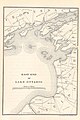
 Lake Ontario, and the southern part of Prince Edward County, in 1836.png 420 × 261; 173 KB
-
 Location of Calf Pasture Shoals in Presqu'ile Bay.png 427 × 234; 156 KB
-
-
 Map of Huron Country, 1631–51 WDL9557.png 1,236 × 1,024; 2.02 MB
-
 Map of Iroquois Five Nations and Mission Sites 1656-1684 by John S. Clark 1879.png 5,711 × 4,926; 13.35 MB
-
-
 Map of the North Shore of Lake Ontario, the Trent River, and Rice Lake.jpg 1,920 × 1,367; 403 KB
-

-
-
-
 Niagara and Onondoga escarpments, 1825.jpg 567 × 360; 115 KB
-
 Nouveau plan du lac Ontario depuis le fort Frontenac jusqu'a Chouayguin.jpg 4,700 × 4,924; 7.83 MB
-
 Part of Ward 1. (Plate T.) NYPL1582658.tiff 7,230 × 4,944; 102.27 MB
-
 Plan of Dundas Street from Burlington Bay to the River Trent (I0030721).jpg 27,811 × 6,280; 94.66 MB
-
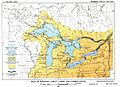
 Plate 21 - Glacial Lake Algonquin and its Correlatives (USGS 1915).JPG 1,094 × 852; 205 KB
-
-

-
 Proposed harbour of refuge, Weller's Bay, 1861.png 429 × 227; 134 KB
-
 Railway map of Canada West.jpg 1,105 × 1,105; 1.76 MB
-

-
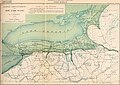
 The harbours and ports of Lake Ontario (1857) (14750892036).jpg 4,352 × 2,712; 1.43 MB
-
 The story of the Hurons (1915) (14592891580).jpg 3,808 × 2,672; 2.04 MB
-

-
 Tribal nations in NW New York Province.jpg 1,477 × 1,037; 215 KB
-
 Upper Canada and the Iroquois Confederacy.jpg 1,050 × 1,531; 303 KB
-

.jpg)

%27_(11226109926).jpg)
.jpg)
_(19178591880).jpg)
%27_(11244812526).jpg)
.jpg)
_(20774675072).jpg)
_(14775288113).jpg)
_(18743935884).jpg)
_(18745844623).jpg)
_(18745848703).jpg)
_(19180315509).jpg)
_(19360374292).jpg)
_(19366488305).jpg)

.jpg)
.jpg)
.jpg)


_(1890)_(20615800022).jpg)


.jpg)
,_from-_The_archeological_history_of_New_York_(Page_47)_BHL21855789_(cropped).jpg)


.JPG)
_or_1917_Nipissing_Great_Lakes_%26_correletives.JPG)


_(14750892036).jpg)
_(14592891580).jpg)


.jpg)