Category:Maps of subdivisions of the Republic of the Congo
Jump to navigation
Jump to search
Countries of Africa: Algeria · Benin · Botswana · Burkina Faso · Cameroon · Cape Verde · Chad · Republic of the Congo · Equatorial Guinea · Ethiopia · Gabon · Ghana · Guinea · Ivory Coast · Kenya · Lesotho · Liberia · Madagascar · Morocco · Mozambique · Namibia · Niger · Rwanda · Sierra Leone · Somalia · South Africa · South Sudan · Sudan · Tanzania · Togo · Uganda · Zambia · Zimbabwe
Limited recognition: Ambazonia
Limited recognition: Ambazonia
Subcategories
This category has the following 2 subcategories, out of 2 total.
Media in category "Maps of subdivisions of the Republic of the Congo"
The following 3 files are in this category, out of 3 total.
-
 Congo regions 1967-1980.png 300 × 368; 12 KB
-
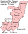 Congo regions 1980-1995.png 300 × 368; 12 KB
-
 Congo regions named.png 300 × 337; 14 KB


