Category:2014 maps of France
Jump to navigation
Jump to search
Countries of Europe: Armenia‡ · Belarus · Belgium · Bosnia and Herzegovina · Bulgaria · Denmark · Estonia · France‡ · Georgia‡ · Germany · Greece · Iceland · Republic of Ireland · Italy · Kazakhstan‡ · Latvia · Moldova · Montenegro · Netherlands‡ · Norway · Romania · Russia‡ · Serbia · Spain‡ · Sweden · Switzerland · Turkey‡ · Ukraine · United Kingdom
‡: partly located in Europe
‡: partly located in Europe
Media in category "2014 maps of France"
The following 17 files are in this category, out of 17 total.
-
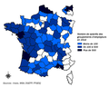 Carte nombre salariés groupement d'employeurs 2014.png 693 × 554; 165 KB
-
 Carte Territoire SICTOM 2014.png 1,886 × 1,648; 100 KB
-
 Carte Territoire SICTOM2014.png 1,136 × 1,002; 342 KB
-
 ECDM 20140128 Europe Events.pdf 1,625 × 1,125; 568 KB
-
 ECDM 20140204 Europe SevereWeather.pdf 1,625 × 1,125; 670 KB
-
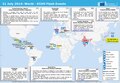
 ECDM 20140429 World Events.pdf 1,625 × 1,125; 472 KB
-
 ECDM 20140610 Europe SevereWeather.pdf 1,625 × 1,125; 503 KB
-
 ECDM 20140731 World Events.pdf 1,625 × 1,125; 366 KB
-
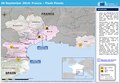 ECDM 20140930 France FlashFloods.pdf 1,625 × 1,125; 584 KB
-
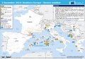
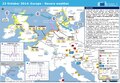 ECDM 20141023 Europe SevereWeather.pdf 1,625 × 1,125; 659 KB
-
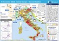 ECDM 20141106 CentralEurope SevereWeather.pdf 1,625 × 1,125; 620 KB
-
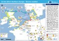
 ECDM 20141117 EU SevereWeather.pdf 1,625 × 1,125; 575 KB
-
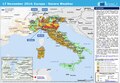
 ECDM 20141128 Europe SevereWeather.pdf 1,625 × 1,125; 534 KB
-
 ECDM 20141202 Europe SevereWeather.pdf 1,625 × 1,125; 676 KB
-
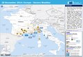
 ECDM NorthernEurope SevereWeather 20141022.pdf 1,625 × 1,125; 450 KB
-
 Réseau autoroutier français - 2014.svg 1,195 × 1,179; 369 KB
-
 SICTOM-CARTEterritoire2014.png 1,321 × 1,061; 433 KB


