File:Drive time isochrones airports northern Finland.png
Jump to navigation
Jump to search

Size of this preview: 800 × 566 pixels. Other resolutions: 320 × 226 pixels | 640 × 453 pixels | 1,024 × 724 pixels | 1,280 × 905 pixels | 2,560 × 1,810 pixels | 3,507 × 2,480 pixels.
Original file (3,507 × 2,480 pixels, file size: 4.35 MB, MIME type: image/png)
Captions
Captions
Add a one-line explanation of what this file represents
Summary[edit]
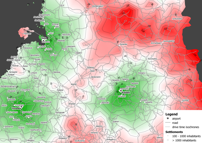
| Description | Drive time isochrones around airports in northern Finland |
| Date | |
| Source | Free and Open Source GIS Ramblings using spatial data (roads and locations) © National Land Survey of Finland 2011 |
| Author | Anita Graser |
Licensing[edit]
I, the copyright holder of this work, hereby publish it under the following license:
This file is licensed under the Creative Commons Attribution 3.0 Unported license.
- You are free:
- to share – to copy, distribute and transmit the work
- to remix – to adapt the work
- Under the following conditions:
- attribution – You must give appropriate credit, provide a link to the license, and indicate if changes were made. You may do so in any reasonable manner, but not in any way that suggests the licensor endorses you or your use.
File history
Click on a date/time to view the file as it appeared at that time.
| Date/Time | Thumbnail | Dimensions | User | Comment | |
|---|---|---|---|---|---|
| current | 13:12, 22 March 2012 | | 3,507 × 2,480 (4.35 MB) | Trevj (talk | contribs) | {{Information |Description= |Source=[http://underdark.wordpress.com/2011/02/12/drive-time-isochrones/ Free and Open Source GIS Ramblings] |Date=2011-02-12 |Author=Anita Graser |Permission= |other_versions= }} == Licensing == {{Free screenshot}} |
You cannot overwrite this file.
File usage on Commons
The following 2 pages use this file:
File usage on other wikis
The following other wikis use this file:
- Usage on en.wikipedia.org
- Usage on es.wikipedia.org
- Usage on it.wikipedia.org
- Usage on sv.wikipedia.org