File:Draining Earth's oceans.ogv
Jump to navigation
Jump to search
Size of this JPG preview of this OGG file: 800 × 400 pixels. Other resolutions: 320 × 160 pixels | 640 × 320 pixels | 1,024 × 512 pixels.
Original file (Ogg Theora video file, length 35 s, 1,024 × 512 pixels, 5.2 Mbps, file size: 21.44 MB)
Captions
Captions
Add a one-line explanation of what this file represents
| Description |
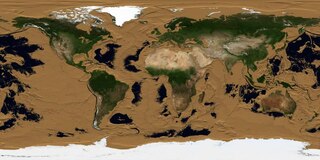
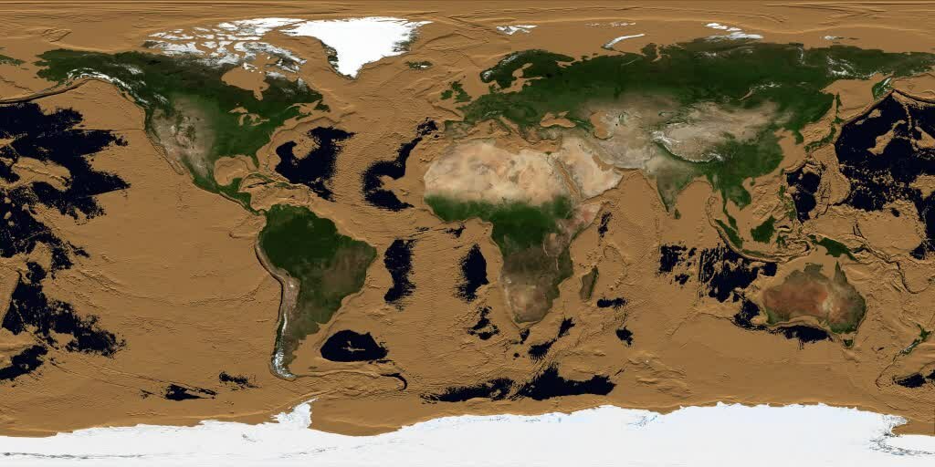
Animation of the draining of the Earth's oceans. The first frame indicates no decrease and the second frame drains all water above sea level. Each subsequent frame represents a 10 meter drop in the level of the Earth's oceans. Three fifths of the Earth's surface is under the ocean, and the ocean floor is as rich in detail as the land surface with which we are familiar. This animation simulates a drop in sea level that gradually reveals this detail. As the sea level drops, the continental shelves appear immediately. They are mostly visible by a depth of 140 meters, except for the Arctic and Antarctic regions, where the shelves are deeper. The mid-ocean ridges start to appear at a depth of 2000 to 3000 meters. By 6000 meters, most of the ocean is drained except for the deep ocean trenches, the deepest of which is the Marianas Trench at a depth of 10,911 meters. |
|||||
| Date | ||||||
| Source |
|
|||||
| Author |
NASA/Goddard Space Flight Center Scientific Visualization Studio The Blue Marble Next Generation data is courtesy of Reto Stockli (NASA/GSFC) and NASA's Earth Observatory. |
|||||
| Permission (Reusing this file) |
|

File history
Click on a date/time to view the file as it appeared at that time.
| Date/Time | Thumbnail | Dimensions | User | Comment | |
|---|---|---|---|---|---|
| current | 15:06, 10 July 2012 | 35 s, 1,024 × 512 (21.44 MB) | Prof. Professorson (talk | contribs) | {{Information |Description=Animation of the draining of the en:Earth's en:oceans. The first frame indicates no decrease and the second frame drains all water above sea level. Each subsequent frame represents a 10 meter drop in the level of ... |
You cannot overwrite this file.
File usage on Commons
There are no pages that use this file.