File:Crisis salina del Messiniense.ogv
Original file (Ogg multiplexed audio/video file, Theora/Vorbis, length 1 min 14 s, 1,440 × 1,080 pixels, 2.06 Mbps overall, file size: 18.21 MB)
Captions
Captions
Summary[edit]
| Description |
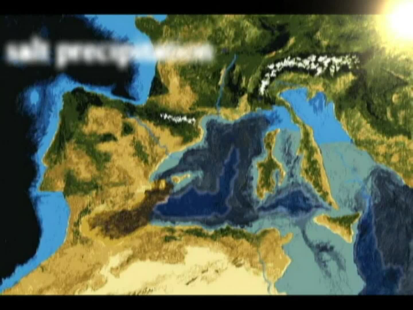
Español: La animación ilustra la crisis salina del Messiniense (Mediterráneo), que tuvo lugar en la época geológica del Mioceno, caracterizada por una acumulación masiva de sal en el fondo marino y que probablemente incluyó un periodo de desecación casi completa (minuto 00:49).
Una posible causa de la clausura de la conexión con el Atlántico fue el desenganche y hundimiento de una placa tectónica subducida (minuto 00:13), en combinación con cambios en el nivel del mar (minuto 00:28). Tras la desconexión completa entre el Oceano Atlantico y el Mar Mediterráneo (minuto 00:31) hubo una rápida caída del nivel del Mediterráneo al cancelarse el aporte de agua que provenía del Atlántico. Los ríos que descargaban sus aguas al mar pasaron a recorrer el fondo marino produciendo profundas gargantas en sus propios deltas. La evaporación (minuto 00:35) produjo la deposición de grandes cantidades de sal en el fondo marino (minuto 00:39). Durante el periodo en el que presumiblemente el nivel del Mediterráneo estaba unos 1200-1500 metros bajo el actual, algunos mamíferos transitaron entre Europa y Africa en la zona del Estrecho de Gibraltar (minuto 00:44). Se cree que la crisis salina terminó con una inundación de enormes dimensiones debido a la entrada de aguas Atlánticas hace unos 5,33 millones de años, a través de un paso abierto en el actual Estrecho de Gibraltar (minuto 00:52). Al quedar el estrecho bajo el nivel del Atlántico, éste rebosó sobre el Mediterráneo y la erosión producida por esas aguas excavó una garganta que se fue haciendo más grande y por tanto retroalimentándose, acabando el proceso en un rellenado catastrófico que pudo durar tan sólo unos meses (minuto 01:10).
Italiano: L'animazione illustra la crisi di salinità del Messiniense nel Mar Mediterraneo che ebbe luogo nell'epoca geologica del Mioceno, caratterizzata per l'accumulazione di masse di sale sul suo fondo e che probabilmente incluse un periodo di disseccazione quasi completa (minuto 00:49)
Una possibile causa de la conseguente chiusura della connessione con l'Atlantico è la rimozione della placca sprofondante (slab rollback) durante un fenomeno di subduzione. (minuto 00:13) in combinazione al cambio del livello del mare (minuto 00:28). In seguito alla chiusura completa tra l'Oceano Atlantico e il Mar Mediterraneo (minuto 00:31) il livello del Mar Mediterraneo calò rapidamente proprio perché non c'era più l'apporto di acqua che proveniva dall'Atlantico. I fiumi che sfociavano nel mare, cominciarono a percorrere il fondo marino creando profondi solchi e cascate nei propri delta. L'evaporazione (minuto 00:35) produsse il deposito di grandi quantità di sale sul fondo del mare (minuto 00:39). Presumibilmente, durante il periodo in cui il livello del Mediterraneo era 1500-1200 metri più basso di quello attuale, alcuni mammiferi transitarono tra l'Africa e l'Europa attraverso l'attuale Stretto di Gibilterra. (minuto 00:44). Si crede che la crisi salina terminò con una inondazione di enormi dimensioni dell'Atlantico nel Mar Mediterraneo 5,33 milioni di anni fa, attraverso un passaggio aperto nell'attuale Stretto di Gibilterra (minuto 00:52). Quando lo stretto si abbassò fino al livello del mare, l'Atlantico traboccò sul Mediterraneo e l'erosione prodotta da queste acque scavò un solco sempre più grande, terminando il processo di riempimento catastrofico, che durò solo in pochi mesi. (minuto 01:10).
English: The animation shows the salinity crisis of Messiniense in the Mediterranean Sea, that took place in the Miocene geological era, characterized by the accumulation of masses of salt on its bottom and probably including a period of almost complete desiccation (00:49 minutes)
A possible cause of the subsequent closure of the connection with the Atlantic is the removal of plaque collapsing (slab rollback) during a phenomenon of subduction. (0:13 minute) in combination to the change of sea level (minute 0:28). Following the complete closure between the Atlantic Ocean and the Mediterranean Sea (0:31 minutes) the level of the Mediterranean Sea dropped rapidly just because there was no supply of water coming from the Atlantic. The rivers that flowed into the sea, began to run the seabed creating deep ruts and waterfalls in its delta. The evaporation (0:35 minutes) produced the storage of large amounts of salt on the sea bottom (0:39 minutes). Presumably, during the period in which the level of the Mediterranean Sea was 1500-1200 meters lower than today, some mammals passed through Africa and Europe, through the present Gibraltar Strait. (minute 0:44). It is believe that the crisis saline, ended with a flood of enormous dimensions of the Atlantic in the Mediterranean Sea 5.33 million years ago, through an passage opened in the current Straits of Gibraltar (minute 0:52). When the strait collapsed to the level of the sea, the Atlantic overflowed in the Mediterranean Sea and the water, the erosion due to the waters dug a groove getting bigger, finishing the filling process catastrophic, that lasted only few months. (minute 1:10).
|
| Date | |
| Source | Own work |
| Author |
Obra derivada de / Lavoro derivato / Derivative work: |

|
This image was provided to Wikimedia Commons as a contribution
from a centre offering art training thanks to a collaboration between UCAC2 and Wikimedia España.
|
Licensing[edit]
- You are free:
- to share – to copy, distribute and transmit the work
- to remix – to adapt the work
- Under the following conditions:
- attribution – You must give appropriate credit, provide a link to the license, and indicate if changes were made. You may do so in any reasonable manner, but not in any way that suggests the licensor endorses you or your use.
- share alike – If you remix, transform, or build upon the material, you must distribute your contributions under the same or compatible license as the original.
File history
Click on a date/time to view the file as it appeared at that time.
| Date/Time | Thumbnail | Dimensions | User | Comment | |
|---|---|---|---|---|---|
| current | 17:24, 16 June 2013 | 1 min 14 s, 1,440 × 1,080 (18.21 MB) | FedericaBri (talk | contribs) | He cambiado el tamaño del vídeo y las imágenes de camellos y roedores / Ho cambiato la dimensione del video e le immagini dei cammelli e dei roditori / I changed the size of the video and the images of camels and rodents | |
| 16:48, 16 June 2013 | 1 min 14 s, 640 × 480 (8.47 MB) | FedericaBri (talk | contribs) | He cambiado el tamaño del vídeo y las imágenes de camellos y rodatori / Ho cambiato la dimensione del video e le immagini dei cammelli e dei rodatori / I changed the size of the video and the images of camels and rodents | ||
| 13:38, 14 June 2013 | 1 min 13 s, 854 × 480 (3.71 MB) | FedericaBri (talk | contribs) | Reverted to version as of 00:56, 12 June 2013 | ||
| 13:38, 14 June 2013 | 1 min 13 s, 854 × 480 (3.71 MB) | FedericaBri (talk | contribs) | He modificado el tamaño del video | ||
| 00:56, 12 June 2013 | 1 min 13 s, 854 × 480 (3.71 MB) | FedericaBri (talk | contribs) | User created page with UploadWizard |
You cannot overwrite this file.
File usage on Commons
The following page uses this file:
Transcode status
Update transcode statusFile usage on other wikis
The following other wikis use this file:
- Usage on an.wikipedia.org
- Usage on ca.wikipedia.org
- Usage on da.wikipedia.org
- Usage on de.wikipedia.org
- Usage on en.wikipedia.org
- Usage on es.wikipedia.org
- Usage on fr.wikipedia.org
- Discussion:Crise de salinité messinienne
- Wikipédia:Le Bistro/4 juillet 2013
- Wikipédia:Statistiques des anecdotes de la page d'accueil/Visibilité des anecdotes (2020)
- Wikipédia:Statistiques des anecdotes de la page d'accueil/Visibilité des anecdotes (2020)/2020 11
- Projet:Aide et accueil/Twitter/Tweets/archives/novembre 2020
- Discussion:Crise de salinité messinienne/LSV 19546
- Wikipédia:Le saviez-vous ?/Archives/2020
- Usage on gl.wikipedia.org
- Usage on hy.wikipedia.org
- Usage on it.wikipedia.org
- Usage on nl.wikipedia.org
- Usage on no.wikipedia.org
- Usage on outreach.wikimedia.org
- WikiArS/Gallery
- WikiArS/Case studies
- WikiArS/Case studies/ca
- Dvdgmz/Workshop/Case studies-cat
- WikiArS/Case studies/en
- Translations:WikiArS/Case studies/6/en
- WikiArS/Case studies/diq
- WikiArS/Gallery/Mosaic
- WikiArS/Case studies/fr
- WikiArS/Case studies/zh
- WikiArS/Case studies/pl
- WikiArS/Case studies/eo
- WikiArS/Case studies/id
- WikiArS/Case studies/de
- Usage on sr.wikipedia.org
- Usage on su.wikipedia.org
- Usage on sv.wikipedia.org
- Usage on www.wikidata.org
- Usage on wikimania2013.wikimedia.org