Category:Maps of the Caliphate
Jump to navigation
Jump to search
English: Maps of the Caliphates — historic Islamic empires in the Western Asia, Central Asia, West Africa, North Africa, and southern Europe.
- Some are the largest empires the world had yet seen, and are among the largest contiguous empires ever to exist.
- The Caliphates' territories fluctuated across the:
- Near East—Levant, and Middle East—Arabian Peninsula.
- Iranian Plateau—Persia, and southern Central Asia.
- Horn of Africa and central-eastern African coast
- North African Maghreb and Sahara, and the sub-Saharan Sahel
- Iberian Peninsula—Al-Andalus.
Subcategories
This category has the following 9 subcategories, out of 9 total.
A
- Maps of Almoravid dynasty (44 F)
F
- Maps of the Fatimid Caliphate (36 F)
M
- Maps of the Almohad Caliphate (51 F)
O
- Old maps of the Caliphate (38 F)
R
- Maps of the Rashidun Caliphate (115 F)
U
Pages in category "Maps of the Caliphate"
This category contains only the following page.
Media in category "Maps of the Caliphate"
The following 19 files are in this category, out of 19 total.
-
 MACCOUN(1899) p211 MOSLEM JERUSALEM - 636 TO 1099 A.D. BAIT-AL-MAKDIS.jpg 1,978 × 3,562; 3.08 MB
-
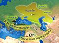 7. yüzyıl Hazarlar.jpg 1,905 × 1,376; 2.31 MB
-
 A history of Rome (1917) (14764027025).jpg 1,894 × 2,922; 827 KB
-
 Abbasid Caliphate, al-Saffah period(751).png 1,394 × 971; 67 KB
-
 Age of the Caliphs-recolored (transparent).svg 900 × 413; 611 KB
-
 Age of the Caliphs-recolored.png 766 × 350; 96 KB
-
 Ancient Khorasan highlighted.jpg 373 × 320; 58 KB
-
 Conquêtes musulmanes.png 1,024 × 634; 204 KB
-
 Dawn of Islam (after 100 A.H).JPG 3,109 × 2,448; 1.48 MB
-
 Dawn of Islam.jpg 3,109 × 2,448; 1.48 MB
-

-
 Expansion of Islam (Atlas of European history, 1909).PNG 1,218 × 842; 1.17 MB
-
 Islam e imperio islámico.jpg 1,554 × 1,171; 644 KB
-
 Mazyar and Babak map.png 1,354 × 750; 1.39 MB
-
 Putz120.jpg 800 × 261; 74 KB
-
 Second Fitna Territorial Control Map ca 686.png 2,143 × 1,392; 714 KB
-
 Sind Eighth Century.svg 600 × 450; 428 KB
-
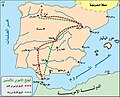 خريطة الفتح الأموي للأندلس.jpg 707 × 571; 224 KB
-
 قلمرو مسلمانان.jpeg 300 × 154; 15 KB
_p211_MOSLEM_JERUSALEM_-_636_TO_1099_A.D._BAIT-AL-MAKDIS.jpg)

_(14764027025).jpg)
.png)


.JPG)

.jpg)
.PNG)


.svg)
Categories:
- Caliphates
- Maps of empires
- Maps of the history of the Levant
- Maps of the history of the Middle East
- Maps of the history of North Africa
- Maps of the history of Africa by former country
- Maps of the history of Asia
- Maps of the history of Europe by former country
- Maps of the history of Afghanistan
- Maps of the history of Armenia
- Maps of the history of Azerbaijan
- Maps of the history of Bahrain
- Maps of the history of Cyprus
- Maps of the history of Egypt
- Maps of the history of Georgia
- Maps of the history of Iran
- Maps of the history of Iraq
- Maps of the history of Israel
- Maps of the history of Jordan
- Maps of the history of Kuwait
- Maps of the history of Kyrgyzstan
- Maps of the history of Lebanon
- Maps of the history of Libya
- Maps of the history of Morocco
- Maps of the history of Northern Cyprus
- Maps of the history of Oman
- Maps of the history of Pakistan
- Maps of the history of Palestine
- Maps of the history of Qatar
- Maps of the history of Tajikistan
- Maps of the history of Tunisia
- Maps of the history of Turkey
- Maps of the history of Turkmenistan
- Maps of the history of Saudi Arabia
- Maps of the history of Syria
- Maps of the history of the United Arab Emirates
- Maps of the history of Uzbekistan
- Maps of the history of Yemen