Category:Maps of states of the Weimar Republic
Jump to navigation
Jump to search
Subcategories
This category has the following 11 subcategories, out of 11 total.
A
- Maps of Anhalt (40 F)
B
L
M
- Maps of Mecklenburg-Schwerin (13 F)
- Maps of Mecklenburg-Strelitz (13 F)
P
T
- Maps of Thuringia (1920–1952) (24 F)
W
Media in category "Maps of states of the Weimar Republic"
This category contains only the following file.
-
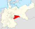 Claimed territory of the Soviet Republic of Saxony.png 1,014 × 849; 232 KB
