Category:Maps connecting Australia and Tasmania
Jump to navigation
Jump to search
Media in category "Maps connecting Australia and Tasmania"
The following 31 files are in this category, out of 31 total.
-
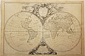
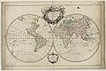
 1744 Bowen Map of the World in Hemispheres - Geographicus - World-bowen-1744.jpg 3,697 × 2,174; 2.48 MB
-

-

-

-
 1757 – G. R. Vaugondy – Orbis Vetus.jpg 4,935 × 3,307; 9.13 MB
-

-

-

-
 AMH-5546-NA Map showing the journeys of Abel Tasman.jpg 2,400 × 1,871; 693 KB
-
-
 Burgerzaal - Australië.JPG 3,264 × 2,448; 1.62 MB
-

-

-
 Great Burgerzaal Map and Celestial Map.jpg 13,520 × 3,961; 19.4 MB
-
 Great Burgerzaal Map.png 2,321 × 1,200; 7.63 MB
-

-

-
 Mappe-monde par le Sr Robert de Vaugondy - btv1b84909279.jpg 7,210 × 4,504; 5.6 MB
-
-
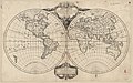
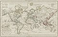
 Mappemonde ou Description du globe terrestre (4072626326).jpg 2,000 × 1,419; 2.95 MB
-
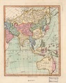 Modern Asia (1796).tif 1,024 × 1,287; 3.77 MB
-

-
-

-

-

-

-
 Tasmanmap1644.jpg 3,236 × 2,516; 2.83 MB
-

-
 Nouvel atlas portatif 1790 (84250726).jpg 11,909 × 7,373; 10.14 MB
-
 Nouvel atlas portatif 1790 (84251201).jpg 11,973 × 7,408; 10.8 MB

.jpg)


_ou_du_nouveau_(-de_l%27ancien)_monde_-_publi%C3%A9_par_le_Sr_d%27Anville..._-_btv1b53006855m_(2_of_2).jpg)


.jpg)


.jpg)
.jpg)

_Robert_de_Vaugondy_G%C3%A9ographe_ord(inaire)_du..._-_btv1b550137444_(016_of_183).jpg)
_Robert_de_Vaugondy_G%C3%A9ographe_ord(inaire)_du..._-_btv1b550137444_(022_of_183).jpg)
_Robert_de_Vaugondy_G%C3%A9ographe_ord(inaire)_du..._-_btv1b550137444_(025_of_183).jpg)


.jpg)
.jpg)