Category:DART
Jump to navigation
Jump to search
English: This category relates to images and illustrations released under a CC-BY licence by the DART project. Detection of Archaeological Residues using remote sensing Techniques (DART) was a three year, £815,000 Science and Heritage funded initiative led by the School of Computing at the University of Leeds. DART concluded in September 2013. The Science and Heritage programme is funded jointly by the Arts and Humanities Research Council (AHRC) and the Engineering and Physical Sciences Research Council (EPSRC). To examine the complex problem of heritage detection DART has attracted a consortium consisting of 25 key heritage and industry organisations and academic consultants and researchers from the areas of computer vision, geophysics, remote sensing, knowledge engineering and soil science.
Media in category "DART"
The following 47 files are in this category, out of 47 total.
-
 1984 Kimmel Holson NCTR TR 6015.pdf 1,275 × 1,650, 32 pages; 3.51 MB
-

-
 Archaeological use of EM spectrum.svg 1,050 × 743; 101 KB
-
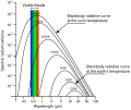 Blackbody emission.svg 512 × 427; 20 KB
-
 BoxWhiskerPlotsCCJune11-June12.svg 2,604 × 1,492; 81 KB
-
 Classification Schema.svg 1,050 × 743; 33 KB
-
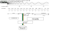
 DART Measurements Plan.svg 1,052 × 744; 668 KB
-
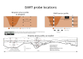 DART Measurements Profile.svg 1,052 × 744; 785 KB
-
 DART UML DART 2011 2013 RAW.svg 17,646 × 8,929; 123 KB
-
 Decreasing spatial resolution from l715m panchromatic.svg 1,052 × 744; 3.79 MB
-
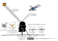
 Detection of archaeological features from an aerial platform.svg 1,050 × 740; 310 KB
-
 Diurnal thermal variation.svg 1,050 × 740; 41 KB
-
 EM Spectrum Properties reflected.svg 675 × 400; 158 KB
-
 Empiracle Remote Sensing Analysis.svg 1,052 × 744; 777 KB
-
 Evidence And Theory 02.svg 1,200 × 8,000; 94 KB
-
 FlashResPlan3D.svg 946 × 362; 108 KB
-
 FormationProcessesAndArchaeologicalDetection.svg 1,052 × 1,488; 2.06 MB
-
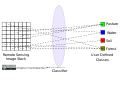
 Hyperspectral And Frame Camera Detection Arrays.svg 1,050 × 743; 210 KB
-

-
 Mixed pixel.svg 1,050 × 743; 32 KB
-
 Mono multi and hyperspectral.svg 744 × 818; 244 KB
-
-
 MS and HS scanning systems.svg 765 × 990; 194 KB
-
 Multi and Hyper spectral imaging systems.svg 765 × 990; 196 KB
-
 Multi Hyper-spectral Image feature space.svg 1,050 × 743; 86 KB
-
 Openness in archaeology.svg 1,052 × 744; 8 KB
-
 Photon wavelength.svg 744 × 1,053; 36 KB
-
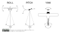 Pitch Roll and Yaw.svg 1,050 × 743; 60 KB
-
 Pixel By Pixel Footprint For Imagery.svg 932 × 756; 19 KB
-
 Plant Biology Experiment in Archaeology.svg 1,050 × 740; 1.17 MB
-
 Radiometric Resolution.svg 1,052 × 744; 5.02 MB
-
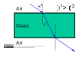 RefractionExample.svg 1,050 × 740; 53 KB
-
 Relationship pixel size and mixed pixels.svg 740 × 1,050; 808 KB
-
 Remote Sensing Energy Interaction Schematic.svg 1,050 × 740; 396 KB
-
 Shortwave energy through atmosphere.svg 1,050 × 740; 29 KB
-
 Solar spectrum cs.svg 800 × 600; 47 KB
-
 Solar spectrum en.svg 800 × 600; 49 KB
-
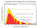 Solar spectrum es.svg 800 × 600; 47 KB
-
 Specular And Diffuse Reflection.svg 1,005 × 405; 81 KB
-
 Tiwnprobe Schematic.svg 703 × 369; 102 KB
-
 U.S. Air Force Transports USAID Urban Search and Recue Team to Nepal (17137947179).jpg 1,600 × 1,065; 260 KB
-

-
 USAID DART Member Mike Davis Speaks To Nepali Army (17313596515).jpg 1,224 × 1,632; 573 KB
-

-
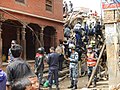 USAID DART Searches Collapsed Structures in Nepal (17136525160).jpg 960 × 720; 127 KB
-
 USAID DART Searches Collapsed Structures in Nepal (17137855459).jpg 960 × 720; 114 KB
-
 USAID DART Searches for Victims in Collapsed Building (17126048580).jpg 4,896 × 3,672; 3.86 MB
_to_a_sensor_after_interaction_with_the_Earth.svg)


.jpg)
.jpg)
.jpg)
.jpg)
.jpg)
.jpg)
.jpg)