File:Piton Fournaise 1972-2000 eruptions-fr.svg
Jump to navigation
Jump to search

Size of this PNG preview of this SVG file: 514 × 599 pixels. Other resolutions: 206 × 240 pixels | 412 × 480 pixels | 659 × 768 pixels | 878 × 1,024 pixels | 1,756 × 2,048 pixels | 1,000 × 1,166 pixels.
Original file (SVG file, nominally 1,000 × 1,166 pixels, file size: 554 KB)
Captions
Captions
Add a one-line explanation of what this file represents
Summary
[edit]| Description |
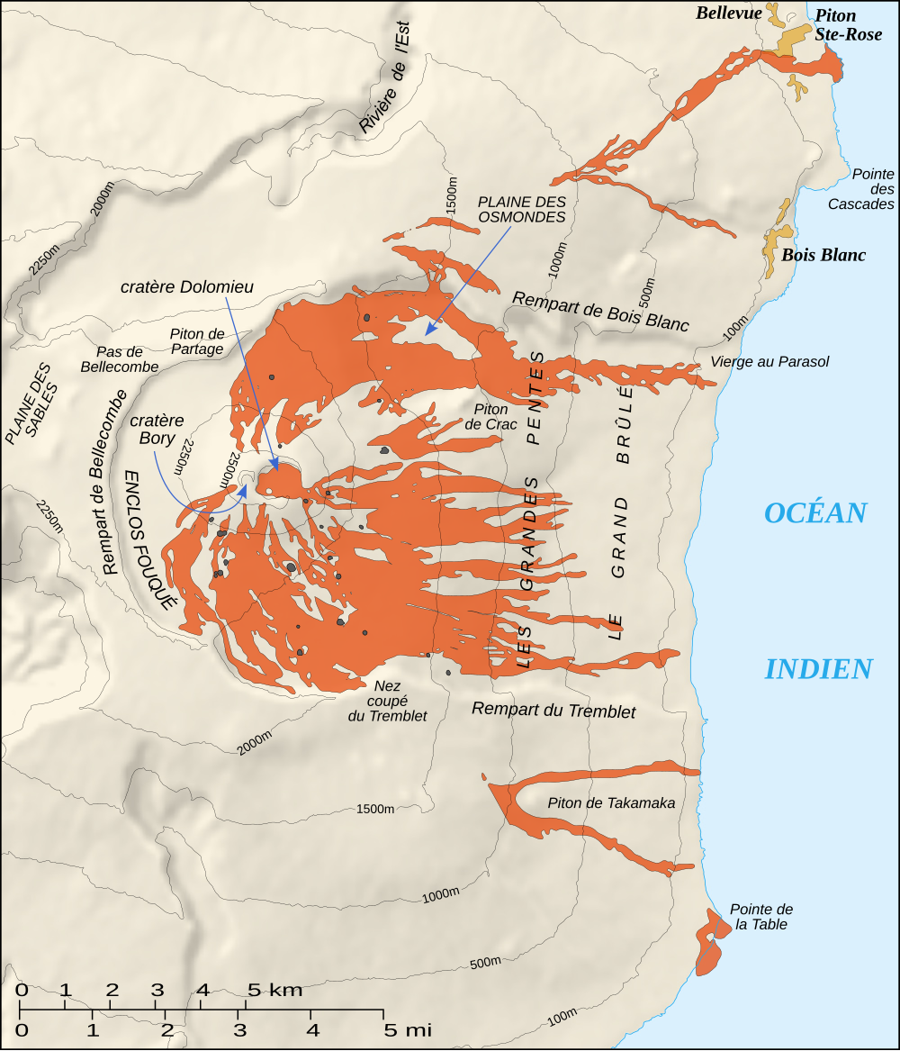
English: Map of the recent eruptions (1972 to 2000) of the Piton de la Fournaise shield volcano on the Réunion island.
Français : Carte des éruptions récentes (1972 à 2000) du volcan du Piton de la Fournaise sur l'île de la Réunion. |
||
| Date | |||
| Source |
Own work ; Shaded relief : NASA Shuttle Radar Topography Mission (SRTM3 v.2) (public domain) edited with 3DEM from Visualization Software LLC ; References used : Maps from the Institut de Physique du Globe de Paris. |
||
| Author | Eric Gaba (Sting - fr:Sting) | ||
| Permission (Reusing this file) |
|
||
| Other versions |
|


|
This SVG file contains embedded text that can be translated into your language, using any capable SVG editor, text editor or the SVG Translate tool. For more information see: About translating SVG files. |
Licensing
[edit]
I, Sting, the copyright holder of this work, hereby publishes it under the following licenses:

|
Permission is granted to copy, distribute and/or modify this document under the terms of the GNU Free Documentation License, Version 1.2 or any later version published by the Free Software Foundation; with no Invariant Sections, no Front-Cover Texts, and no Back-Cover Texts. A copy of the license is included in the section entitled GNU Free Documentation License. |
| This file is licensed under the Creative Commons Attribution-Share Alike 3.0 Unported license. | ||
| Attribution: I, Sting | ||
| ||
| This licensing tag was added to this file as part of the GFDL licensing update. |
This file is licensed under the Creative Commons Attribution-Share Alike 2.5 Generic, 2.0 Generic and 1.0 Generic license.
Attribution: I, Sting
- You are free:
- to share – to copy, distribute and transmit the work
- to remix – to adapt the work
- Under the following conditions:
- attribution – You must give appropriate credit, provide a link to the license, and indicate if changes were made. You may do so in any reasonable manner, but not in any way that suggests the licensor endorses you or your use.
- share alike – If you remix, transform, or build upon the material, you must distribute your contributions under the same or compatible license as the original.
You may select the license of your choice.
File history
Click on a date/time to view the file as it appeared at that time.
| Date/Time | Thumbnail | Dimensions | User | Comment | |
|---|---|---|---|---|---|
| current | 19:35, 23 June 2007 | | 1,000 × 1,166 (554 KB) | Sting (talk | contribs) | Text rendering |
| 18:04, 13 June 2007 |  | 1,000 × 1,166 (551 KB) | Sting (talk | contribs) | Lighter paths ; bugs correction | |
| 17:36, 13 June 2007 |  | 1,000 × 1,166 (989 KB) | Sting (talk | contribs) | {{Information |Description=Map of the recent eruptions (1972 to 2000) of the ''Piton de la Fournaise'' shield volcano on the Réunion island. |Source=Own work ;<br/>Shaded relief : [http://www2.jpl.nasa.gov/s |
You cannot overwrite this file.
File usage on Commons
The following 3 pages use this file:
File usage on other wikis
The following other wikis use this file:
- Usage on es.wikipedia.org
- Usage on fr.wikipedia.org
- Usage on fr.wikivoyage.org
- Usage on pt.wikipedia.org