File:Kaart patat friet frieten.svg
Jump to navigation
Jump to search

Size of this PNG preview of this SVG file: 631 × 599 pixels. Other resolutions: 253 × 240 pixels | 506 × 480 pixels | 809 × 768 pixels | 1,078 × 1,024 pixels | 2,157 × 2,048 pixels | 694 × 659 pixels.
Original file (SVG file, nominally 694 × 659 pixels, file size: 1.35 MB)
Captions
Captions
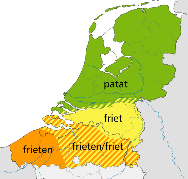
Use of the wordings "patat" or "friet" in Dutch language area, based on map by Jan Stroop, Meertens Institute, 1972
| Description |
Nederlands: Woordgebruik voor staafjes aardappel die in vet gebakken zijn, Nederlands taalgebied, 1972. Gebaseerd op de kaart Patates frites van dialectoloog Jan Stroop als illustratie bij het artikel Weet wat u eet in Proeven van dialect (redactie Veronique de Tier e.a.) Groesbeek 2005, blz. 15-35., gepubliceerd op zijn internetpagina Weet wat u eet en in zijn boek Hun hebben de taal verkwanseld (Athenaeum, 2010). De oorspronkelijke kaart verscheen in 1972 bij Stroop's artikel ‘Een patat mét (..vragen), in Mededelingen van het Instituut voor Dialectologie, Volkskunde en Naamkunde en toont resultaten van een enquête uit dat jaar. Het begon Stroop op te vallen dat ten noorden van de rivieren een andere benaming voorkwam dan hij van huis kende, daarom legde hij als medewerker van het Meertens Instituut de volgende vraag voor aan correspondenten van dat instituut: ‘Hoe noemt men in uw dialekt de staafjes aardappel die in vet gebakken en ook wel in zakjes verkocht worden?’. Er kwamen een kleine 1000 antwoorden.
Deze kaart verschilt van die van Stroop op de volgende punten:
|
| Date | (UTC) |
| Source |
own work, using |
| Author |
|
This file is licensed under the Creative Commons Attribution-Share Alike 3.0 Unported license.
- You are free:
- to share – to copy, distribute and transmit the work
- to remix – to adapt the work
- Under the following conditions:
- attribution – You must give appropriate credit, provide a link to the license, and indicate if changes were made. You may do so in any reasonable manner, but not in any way that suggests the licensor endorses you or your use.
- share alike – If you remix, transform, or build upon the material, you must distribute your contributions under the same or compatible license as the original.
Original upload log
[edit]
This image is a derivative work of the following images:
- File:Benelux_location_map.svg licensed with Cc-by-sa-3.0
- 2011-02-17T18:34:51Z NordNordWest 960x1304 (179133 Bytes) == {{int:filedesc}} == {{Information |Description= {{de|Positionskarte der [[:de:Benelux|Benelux]]-Staaten}} Quadratische Plattkarte, N-S-Streckung 160 %. Geographische Begrenzung der Karte: * N: 53.7° N * S: 49.2° N * W: 2
- File:Netherlands_location_map.svg licensed with Cc-by-sa-3.0, GFDL
- 2011-03-03T17:32:11Z Lencer 888x1001 (230675 Bytes) fix border
- 2008-09-11T16:26:25Z Lencer 888x1001 (235175 Bytes) {{Information |Description= |Source= |Date= |Author= |Permission= |other_versions= }}
- 2008-09-10T15:15:26Z Lencer 888x1001 (235195 Bytes) {{Information |Description= |Source= |Date= |Author= |Permission= |other_versions= }}
- 2008-09-09T18:35:56Z Lencer 888x1001 (234406 Bytes) {{Information |Description= |Source= |Date= |Author= |Permission= |other_versions= }}
- 2008-08-16T12:15:18Z Lencer 888x1001 (234098 Bytes) {{Information |Description= |Source= |Date= |Author= |Permission= |other_versions= }}
- 2008-07-24T11:14:56Z NordNordWest 354x399 (218910 Bytes)
- 2008-07-24T11:10:58Z NordNordWest 354x399 (210601 Bytes)
- 2008-07-24T11:03:52Z NordNordWest 354x399 (219496 Bytes)
- 2008-07-24T10:57:42Z NordNordWest 354x399 (129554 Bytes) {{Information |Description= {{de|Positionskarte der [[:de:Niederlande|Niederlande]]}} Quadratische Plattkarte, N-S-Streckung 160 %. Geographische Begrenzung der Karte: * N: 53.7° N * S: 50.6° N * W: 3.1° O * O: 7.5�
- File:Belgium_location_map.svg licensed with Cc-by-sa-3.0, GFDL
Uploaded with derivativeFX
File history
Click on a date/time to view the file as it appeared at that time.
| Date/Time | Thumbnail | Dimensions | User | Comment | |
|---|---|---|---|---|---|
| current | 11:19, 4 April 2011 | | 694 × 659 (1.35 MB) | Cavit (talk | contribs) | {{Information |Description={{nl|Benaming voor gefrituurde staafjes aardappel in 1972. Gebaseerd op de kaart ''Patates frites'' van Jan Stroop, gepubliceerd op zijn internetpagina [http://www.janstroop.nl/artikelen/Weetwatueet.shtml Weet wat u eet] en in z |
You cannot overwrite this file.
File usage on Commons
There are no pages that use this file.
File usage on other wikis
The following other wikis use this file:
- Usage on nl.wikipedia.org
- Usage on www.wikidata.org