File:NationalitiesOfSoutheasternEuropePallasNagyLexikon.jpg
Original file (695 × 1,136 pixels, file size: 700 KB, MIME type: image/jpeg)
Captions
Captions
Summary
[edit]
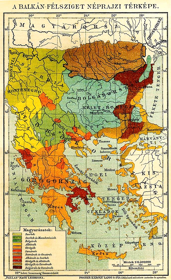
| Description |
Български: Етнографска карта на Югоизточна Европа според унгарски лексикон от края на 19 век. Română: Harta etnografică a Europei de Sud-Est, în limba maghiară, aparută în Marele Lexicon Pallas English: Ethnographic map of Southeastern Europe, in Hungarian, as seen in the Pallas Great Lexicon Magyar: Délkelet Europa, etnikus térkép, a Pallas Nagy Lexiconbol
Етнографска карта на Югоизточна Европа според унгарски лексикон от края на 19 век. |
| Date | |
| Source | Pallas Nagy Lexikon |
| Author | Carl Ludwig "Karoly Lajos" von Posner (1822 - 1887) |
Licensing
[edit]
|
This is a faithful photographic reproduction of a two-dimensional, public domain work of art. The work of art itself is in the public domain for the following reason:
The official position taken by the Wikimedia Foundation is that "faithful reproductions of two-dimensional public domain works of art are public domain". This photographic reproduction is therefore also considered to be in the public domain in the United States. In other jurisdictions, re-use of this content may be restricted; see Reuse of PD-Art photographs for details. {{PD-Art}} template without license parameter: please specify why the underlying work is public domain in both the source country and the United States
(Usage: {{PD-Art|1=|deathyear=''year of author's death''|country=''source country''}}, where parameter 1= can be PD-old-auto, PD-old-auto-expired, PD-old-auto-1996, PD-old-100 or similar. See Commons:Multi-license copyright tags for more information.) | ||||
File history
Click on a date/time to view the file as it appeared at that time.
| Date/Time | Thumbnail | Dimensions | User | Comment | |
|---|---|---|---|---|---|
| current | 18:12, 27 March 2009 | | 695 × 1,136 (700 KB) | Alexandar.R.~commonswiki (talk | contribs) | {{Information |Description={{bg|1=Етнографска карта на Югоизточна Европа според унгарски лексикон от края на 19 век.}} |Source=[http://mek.niif.hu/00000/00060/html/009/pc000985.html Pallas |
You cannot overwrite this file.
File usage on Commons
The following 2 pages use this file:
File usage on other wikis
The following other wikis use this file:
- Usage on bg.wikipedia.org
- Usage on fr.wikipedia.org
Metadata
- Historical maps of ethnic groups in Albania
- Historical maps of ethnic groups in Bulgaria
- Historical maps of ethnic groups in Greece
- Historical maps of ethnic groups in North Macedonia
- Historical maps of ethnic groups in Romania
- Historical maps of ethnic groups in Serbia
- Historical maps of ethnic groups in Turkey
- Maps showing 19th-century history
- Old maps of the Balkans
- Historical maps of ethnic groups in the Balkans