File:Kingdom of Mann and the Isles-en.svg
Jump to navigation
Jump to search

Size of this PNG preview of this SVG file: 571 × 600 pixels. Other resolutions: 229 × 240 pixels | 457 × 480 pixels | 731 × 768 pixels | 975 × 1,024 pixels | 1,950 × 2,048 pixels | 1,297 × 1,362 pixels.
Original file (SVG file, nominally 1,297 × 1,362 pixels, file size: 209 KB)
Captions
Captions
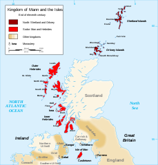
Map of the kingdom of Mann and the Isles, near the end of eleventh century
Summary
[edit]| Description |
English: Map of the kingdom of Mann and the Isles, nearly the end of eleventh century.
Norðr: Shetland and Orkney
Sodor: Man and Hebrides Français : Carte du royaume de Man et des Îles, vers la fin du onzième siècle.
Norðr : Shetland et Orcades
Sodor : Man et Hebrides |
||
| Date | |||
| Source |
Own work based on: British Isles.svg, Mormaerdoms.png and Www.wesleyjohnston.com-users-ireland-maps-historical-map1014.gif |
||
| Author | Sémhur | ||
| Other versions |
Derivative works of this file: Kingdom of Mann and the Isles-es.svg
|
||
| Attribution (required by the license) | © Sémhur / Wikimedia Commons / | ||
| SVG | W3C-validity not checked.
|
||
| Atelier graphique |

| Camera location | | View this and other nearby images on: OpenStreetMap |
|---|
Licensing
[edit]
I, the copyright holder of this work, hereby publish it under the following licenses:
| Copyleft: This work of art is free; you can redistribute it and/or modify it according to terms of the Free Art License. You will find a specimen of this license on the Copyleft Attitude site as well as on other sites. |
This file is licensed under the Creative Commons Attribution-Share Alike 3.0 Unported, 2.5 Generic, 2.0 Generic and 1.0 Generic license.
- You are free:
- to share – to copy, distribute and transmit the work
- to remix – to adapt the work
- Under the following conditions:
- attribution – You must give appropriate credit, provide a link to the license, and indicate if changes were made. You may do so in any reasonable manner, but not in any way that suggests the licensor endorses you or your use.
- share alike – If you remix, transform, or build upon the material, you must distribute your contributions under the same or compatible license as the original.
You may select the license of your choice.
File history
Click on a date/time to view the file as it appeared at that time.
| Date/Time | Thumbnail | Dimensions | User | Comment | |
|---|---|---|---|---|---|
| current | 20:06, 26 December 2015 | | 1,297 × 1,362 (209 KB) | Alphathon (talk | contribs) | Various minor corrections/tweaks |
| 10:06, 15 October 2007 |  | 1,297 × 1,362 (208 KB) | Sémhur (talk | contribs) | {{Information |Description=Map of the kingdom of Mann and the Isles, nearly the end of eleventh century |Source=Own work, from : * Map of British Isles * [[:Image:Mormaerdoms.png|Map of kingdoms of Scotland in the Middle Ages] |
You cannot overwrite this file.
File usage on Commons
The following 4 pages use this file:
File usage on other wikis
The following other wikis use this file:
- Usage on af.wikipedia.org
- Usage on be.wikipedia.org
- Usage on bn.wikipedia.org
- Usage on br.wikipedia.org
- Usage on ca.wikipedia.org
- Usage on cs.wikipedia.org
- Usage on cy.wikipedia.org
- Usage on da.wikipedia.org
- Usage on de.wikipedia.org
- Usage on el.wikipedia.org
- Usage on en.wikipedia.org
- Hebrides
- Isle of Man
- History of the Isle of Man
- Norn language
- Scotland
- Outer Hebrides
- Kingdom of the Isles
- Slate Islands
- Diocese of Sodor and Man
- User:Jnestorius/Regions with significant island landmass
- Earldom of Orkney
- Thorfinn the Mighty
- List of early Germanic peoples
- Norse–Gaels
- Scotland in the High Middle Ages
- Portal:Middle Ages/Selected article
- Portal:Middle Ages/Selected article/10
- Manx runestones
- Viking expansion
- King of Mann
- List of active separatist movements in Europe
- Scottish island names
- Portal:Scotland/Selected article/2012
- Scandinavian Scotland
- Portal:Scotland/Selected article/Week 2, 2012
- Portal:Scotland/Selected article/2016
- Portal:Scotland/Selected article/Week 2, 2016
- Usage on es.wikipedia.org
- Usage on eu.wikipedia.org
- Usage on fi.wikipedia.org
View more global usage of this file.