File:Formación de los países del mundo.png
Jump to navigation
Jump to search
Size of this preview: 800 × 362 pixels. Other resolutions: 320 × 145 pixels | 640 × 290 pixels | 1,024 × 463 pixels | 1,280 × 579 pixels | 2,644 × 1,196 pixels.
Original file (2,644 × 1,196 pixels, file size: 163 KB, MIME type: image/png)
Captions
Captions
Add a one-line explanation of what this file represents
Summary
[edit]
| Description |
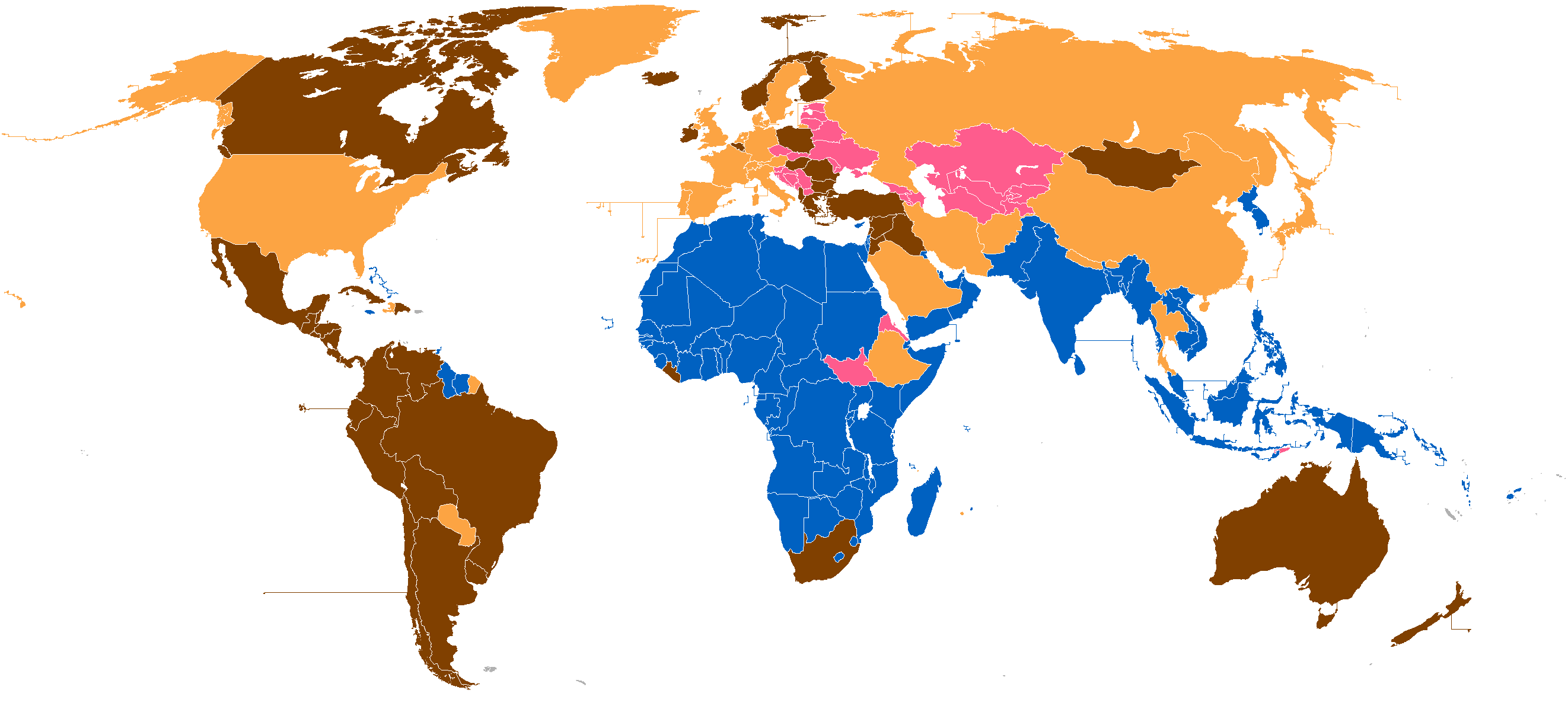
Español: Formación de los países actuales.
Antes de 1815
De 1815 a 1945
De 1945 a 1990
Después de 1990 |
| Date | |
| Source | Own work |
| Author | Fobos92 |
Summary
[edit]
Formación de los países del globo por año de fundación. Basado en Image:BlankMap-World.png. Elaboración propia.
Licensing
[edit]

|
Permission is granted to copy, distribute and/or modify this document under the terms of the GNU Free Documentation License, Version 1.2 or any later version published by the Free Software Foundation; with no Invariant Sections, no Front-Cover Texts, and no Back-Cover Texts. A copy of the license is included in the section entitled GNU Free Documentation License. |
| This file is licensed under the Creative Commons Attribution-Share Alike 3.0 Unported license. | ||
| ||
| This licensing tag was added to this file as part of the GFDL licensing update. |
File history
Click on a date/time to view the file as it appeared at that time.
| Date/Time | Thumbnail | Dimensions | User | Comment | |
|---|---|---|---|---|---|
| current | 22:02, 26 February 2023 | | 2,644 × 1,196 (163 KB) | 5ysksos6 (talk | contribs) | Turquía salia antes de 1815, pero Turquía NO es el Imperio otomano, el Imperio otomano se independizo en 1299, pero Turquía se independizo del Imperio otomano en 1922, también esta Egipto, que salia de 1815 a 1945, pero Egipto era un protectorado, pero con bastante autonomía. English: Turkey appears in the old version like got independence before 1815, but Turkey is NOT the Ottoman Empire, the Ottoman Empire got independence in 1299, but Turkey in 1922 from the Ottomans, also here is Egypt, w... |
| 10:03, 23 January 2018 |  | 2,644 × 1,196 (98 KB) | Maphobbyist (talk | contribs) | Correction Belize gaine independence after 1945. | |
| 12:17, 13 April 2016 |  | 2,644 × 1,196 (141 KB) | Kordas (talk | contribs) | Arreglados Israel y Arabia Saudí | |
| 03:53, 7 January 2013 |  | 2,644 × 1,196 (136 KB) | Maphobbyist (talk | contribs) | Further corrections | |
| 11:53, 25 October 2011 |  | 2,644 × 1,196 (141 KB) | Fobos92 (talk | contribs) | . | |
| 17:47, 6 August 2011 |  | 800 × 370 (156 KB) | Romero13 (talk | contribs) | (Adición de Sudan del Sur (independiente desde 2011), cambio a Argentina (independiente desde 1816) a "de 1815 a 1945" y cambio de color en la leyenda para que concuerde con el mapa (de amarillo a rosado)) | |
| 12:03, 26 August 2010 |  | 800 × 370 (121 KB) | DJ Sturm (talk | contribs) | North Europe | |
| 03:50, 21 May 2008 |  | 800 × 370 (121 KB) | Pruxo (talk | contribs) | {{Information |Description=mapa anterior, pero con más exactitud, albania, guyana francesa (no independiente) groenlandia(no independiente) y argentina (independiente desde 1810-1815) malvinas (no independiente) |Source=self-made |Date= |Author= [[User:P | |
| 03:48, 21 May 2008 |  | 800 × 370 (138 KB) | Pruxo (talk | contribs) | {{Information |Description= |Source=self-made |Date= |Author= Pruxo |Permission= |other_versions= }} | |
| 11:31, 10 November 2005 |  | 1,357 × 628 (58 KB) | Mortadelo2005 (talk | contribs) | Acceso a la independencia de los países del mundo. Basado en [http://commons.wikimedia.org/wiki/Image:BlankMap-World.png Image:BlankMap-World.png]. Elaboración propia. Category:World maps |
You cannot overwrite this file.
File usage on Commons
The following 2 pages use this file:
- Atlas of colonialism
- File:Acceso a la independencia.png (file redirect)
File usage on other wikis
The following other wikis use this file:
- Usage on an.wikipedia.org
- Usage on ast.wikipedia.org
- Usage on ba.wikipedia.org
- Usage on bg.wikipedia.org
- Usage on de.wikipedia.org
- Deutsche Kolonien
- Kolonialismus
- Französische Kolonien
- Niederländische Kolonien
- Spanisches Kolonialreich
- Kolonialmacht
- Dänische Kolonien
- Italienische Kolonien
- Portugiesische Kolonialgeschichte
- Britische Kolonien und Protektorate
- Kolonien und Protektorate der Vereinigten Staaten
- Belgische Kolonien
- Russische Kolonisation
- Vorlage:Navigationsleiste Kolonialmächte
- Japanische Kolonien
- Genueser Kolonien
- Venezianische Kolonien
- Kolonien deutscher Länder vor 1871
- Usage on eo.wikipedia.org
- Usage on es.wikipedia.org
- Usage on es.wikinews.org
- Usage on gn.wikipedia.org
- Usage on hi.wikipedia.org
- Usage on id.wikipedia.org
- Usage on it.wikipedia.org
- Usage on krc.wikipedia.org
- Usage on la.wikipedia.org
- Usage on mg.wikipedia.org
- Usage on oc.wikipedia.org
- Usage on ru.wikipedia.org
- Usage on scn.wikipedia.org
- Usage on uk.wikipedia.org
- Usage on vec.wikipedia.org