File:Dagestan-district.png
Jump to navigation
Jump to search

Size of this preview: 407 × 599 pixels. Other resolutions: 163 × 240 pixels | 326 × 480 pixels | 522 × 768 pixels | 696 × 1,024 pixels | 1,439 × 2,117 pixels.
Original file (1,439 × 2,117 pixels, file size: 50 KB, MIME type: image/png)
Captions
Captions
Add a one-line explanation of what this file represents
Summary
[edit]
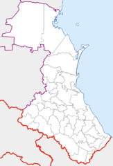
Map of Dagestan (Russia) with district boundaries.
Карта Дагестана с границами районов.
| Description |
Català: Mapa de localització de Daguestan.
Dansk: Dagestan.
Esperanto: Situo sur mapo Ruslando Dagestano.
Suomi: Dagestanin piirikartta.
Hornjoserbsce: LocMap Ruska Dagestan.
Nederlands: Kaart Positiekaart Rusland Dagestan. |
| Date | |
| Source | Own work |
| Author | Koryakov Yuri |
| Other versions | Derivative works of this file: Kurakhsky district locator map.png |
Licensing
[edit]
| I, the copyright holder of this work, release this work into the public domain. This applies worldwide. In some countries this may not be legally possible; if so: I grant anyone the right to use this work for any purpose, without any conditions, unless such conditions are required by law. |
File history
Click on a date/time to view the file as it appeared at that time.
| Date/Time | Thumbnail | Dimensions | User | Comment | |
|---|---|---|---|---|---|
| current | 16:08, 24 June 2008 | | 1,439 × 2,117 (50 KB) | Insider (talk | contribs) | в топку траурную границу (края те же) |
| 19:05, 11 February 2007 |  | 1,439 × 2,117 (49 KB) | Koryakov Yuri (talk | contribs) | Map of Dagestan (Russia) with district boundaries. |
You cannot overwrite this file.
File usage on Commons
The following 2 pages use this file:
File usage on other wikis
The following other wikis use this file:
- Usage on az.wikipedia.org
- Usage on fa.wikipedia.org
- Usage on fi.wikipedia.org
- Usage on hu.wikipedia.org
- Usage on nn.wikipedia.org
- Usage on pt.wikipedia.org
- Usage on ru.wikipedia.org