File:Bagratuni Armenia 1000-en.svg
Jump to navigation
Jump to search

Size of this PNG preview of this SVG file: 800 × 470 pixels. Other resolutions: 320 × 188 pixels | 640 × 376 pixels | 1,024 × 601 pixels | 1,280 × 751 pixels | 2,560 × 1,503 pixels | 2,717 × 1,595 pixels.
Original file (SVG file, nominally 2,717 × 1,595 pixels, file size: 820 KB)
Captions
Captions
Add a one-line explanation of what this file represents
Summary
[edit]| Description |
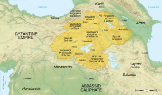
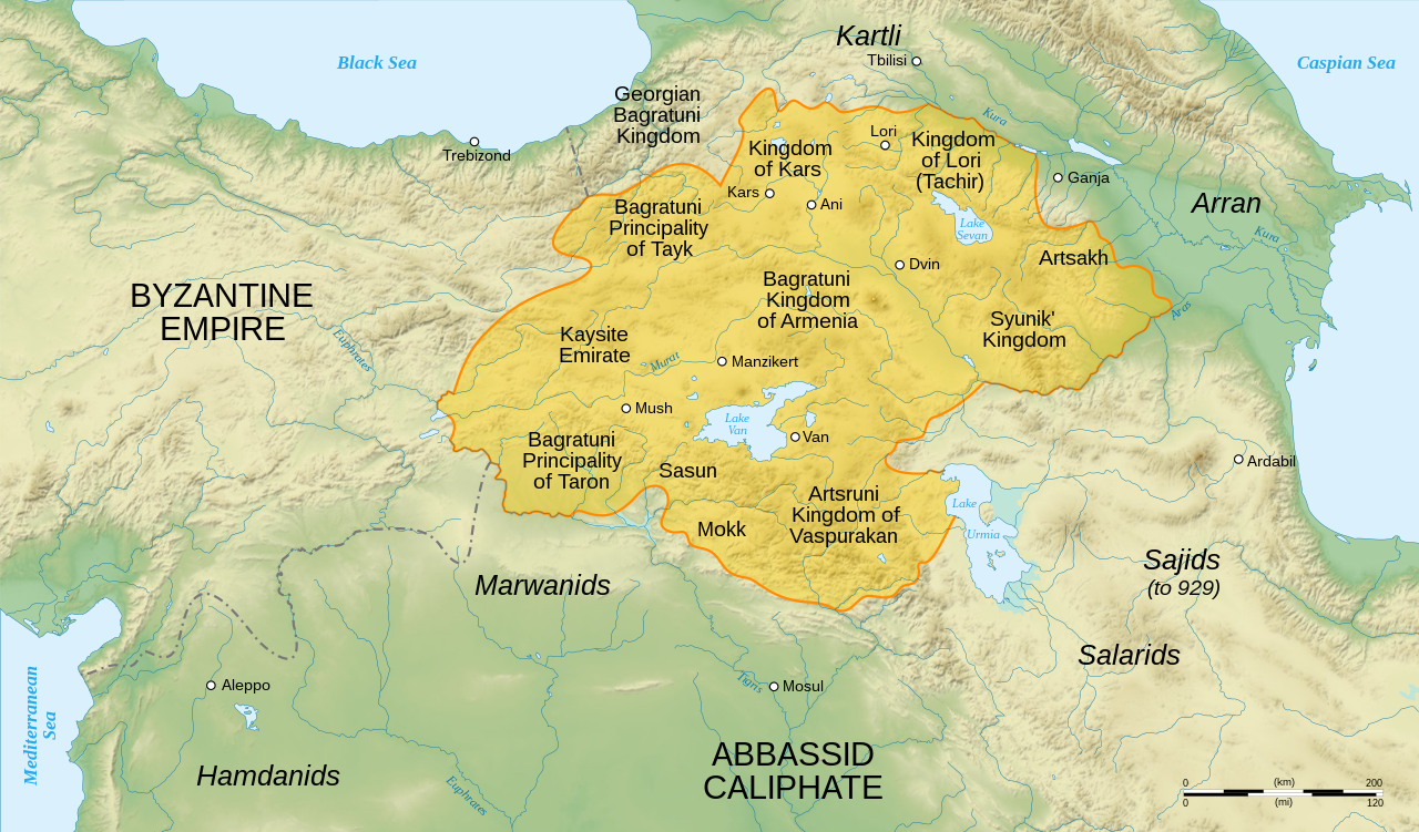
English: English map of Bagratuni Armenia, around the year 1000 AD
Ελληνικά: Η Αρμενία στο μεσαίωνα - χάρτης της δυναστείας Βαγρατιδών το έτος 1000 μ.Χ.
Français : Carte en anglais de l'Arménie bagratide, vers l'an mille. |
| Date | |
| Source |
Data sources :
Softwares used :
Others :
|
| Author | Sémhur ·✉·✍· |
| Other versions |
[]
|


|
This SVG file contains embedded text that can be translated into your language, using any capable SVG editor, text editor or the SVG Translate tool. For more information see: About translating SVG files. |
This W3C-unspecified vector image was created with Inkscape .
Licensing
[edit]
I, the copyright holder of this work, hereby publish it under the following licenses:

|
Permission is granted to copy, distribute and/or modify this document under the terms of the GNU Free Documentation License, Version 1.2 or any later version published by the Free Software Foundation; with no Invariant Sections, no Front-Cover Texts, and no Back-Cover Texts. A copy of the license is included in the section entitled GNU Free Documentation License. |
This file is licensed under the Creative Commons Attribution-Share Alike 3.0 Unported, 2.5 Generic, 2.0 Generic and 1.0 Generic license.
- You are free:
- to share – to copy, distribute and transmit the work
- to remix – to adapt the work
- Under the following conditions:
- attribution – You must give appropriate credit, provide a link to the license, and indicate if changes were made. You may do so in any reasonable manner, but not in any way that suggests the licensor endorses you or your use.
- share alike – If you remix, transform, or build upon the material, you must distribute your contributions under the same or compatible license as the original.
You may select the license of your choice.
File history
Click on a date/time to view the file as it appeared at that time.
| Date/Time | Thumbnail | Dimensions | User | Comment | |
|---|---|---|---|---|---|
| current | 16:15, 20 April 2021 | | 2,717 × 1,595 (820 KB) | Εὐθυμένης (talk | contribs) | File uploaded using svgtranslate tool (https://svgtranslate.toolforge.org/). Added translation for el. |
| 13:01, 23 October 2017 |  | 2,717 × 1,595 (781 KB) | Rs4815 (talk | contribs) | Reverted to version as of 17:32, 10 March 2016 (UTC) vandalism | |
| 07:52, 23 October 2017 |  | 2,717 × 1,595 (776 KB) | Giorgi Balakhadze (talk | contribs) | Taivo if speak about border sources than your version is also unsourced both in SVG and in PNG | |
| 17:32, 10 March 2016 |  | 2,717 × 1,595 (781 KB) | Taivo (talk | contribs) | repeatedly uploaded unsourced version | |
| 16:29, 10 March 2016 |  | 2,717 × 1,595 (776 KB) | Ercwlff (talk | contribs) | are you kidding or what? You all are very biased. first of all Tao was a province of the Kingdom of The Georgians and its rulers were the representatives of Georgian Bagrationi dynasty | |
| 09:01, 27 February 2016 |  | 2,717 × 1,595 (781 KB) | Rs4815 (talk | contribs) | Reverted to version as of 18:05, 13 September 2009 (UTC) | |
| 23:00, 24 February 2016 |  | 2,717 × 1,595 (781 KB) | Ankax Hayastan (talk | contribs) | Надо обсуждать Reverted to version as of 12:31, 27 December 2007 (UTC) | |
| 14:48, 24 February 2016 |  | 2,717 × 1,595 (776 KB) | Ercwlff (talk | contribs) | Doesn't fit the historical truth | |
| 10:41, 9 February 2016 |  | 2,717 × 1,595 (781 KB) | Rs4815 (talk | contribs) | Reverted to version as of 18:05, 13 September 2009 (UTC) restore the original map (by G. Bournoutian from "A Concise History of the Armenian People", map 15) | |
| 16:06, 19 December 2015 |  | 2,717 × 1,595 (776 KB) | Ercwlff (talk | contribs) | corrected. there is no kars kingdom in existence and on wiki. also tao-klarjeti kingdom and the kingdom of Georgians are the same |
You cannot overwrite this file.
File usage on Commons
The following 16 pages use this file:
- Atlas of Armenia
- Atlas of Artsakh
- User:Chumwa/OgreBot/Potential transport maps/2016 February 1-9
- User:Jaqeli/Georgia
- User:Kareyac/Archive/Armenia/2016 February 1-9
- User:Kareyac/Armenia/2016 February 20-29
- User:Kareyac/Armenia/2016 March 1-10
- User:Kareyac/Armenia/2017 October 21-31
- File:BagratuniArmenia1000.png
- File:Bagratuni Armenia 1000-ar.svg
- File:Bagratuni Armenia 1000-en.svg
- File:Bagratuni Armenia 1000-fr.svg
- File:Bagratuni Armenia 1000-hy.svg
- File:Bagratuni Armenia 1000-tr.svg
- Template:Other Versions/Bagratuni Armenia 1000
- Category:Bagratuni Kingdom of Armenia
File usage on other wikis
The following other wikis use this file:
- Usage on af.wikipedia.org
- Usage on ast.wikipedia.org
- Usage on ba.wikipedia.org
- Usage on be.wikipedia.org
- Usage on bg.wikipedia.org
- Usage on ca.wikipedia.org
- Usage on cs.wikipedia.org
- Usage on da.wikipedia.org
- Usage on de.wikipedia.org
- Usage on el.wikipedia.org
- Usage on en.wikipedia.org
- Usage on eo.wikipedia.org
- Usage on es.wikipedia.org
- Usage on et.wikipedia.org
- Usage on eu.wikipedia.org
- Usage on fa.wikipedia.org
- Usage on fr.wikipedia.org
- Usage on gl.wikipedia.org
- Usage on he.wikipedia.org
View more global usage of this file.