File:Ajaria02.png
Jump to navigation
Jump to search

Size of this preview: 800 × 524 pixels. Other resolutions: 320 × 210 pixels | 640 × 419 pixels | 847 × 555 pixels.
Original file (847 × 555 pixels, file size: 30 KB, MIME type: image/png)
Captions
Captions
Add a one-line explanation of what this file represents
Summary
[edit]
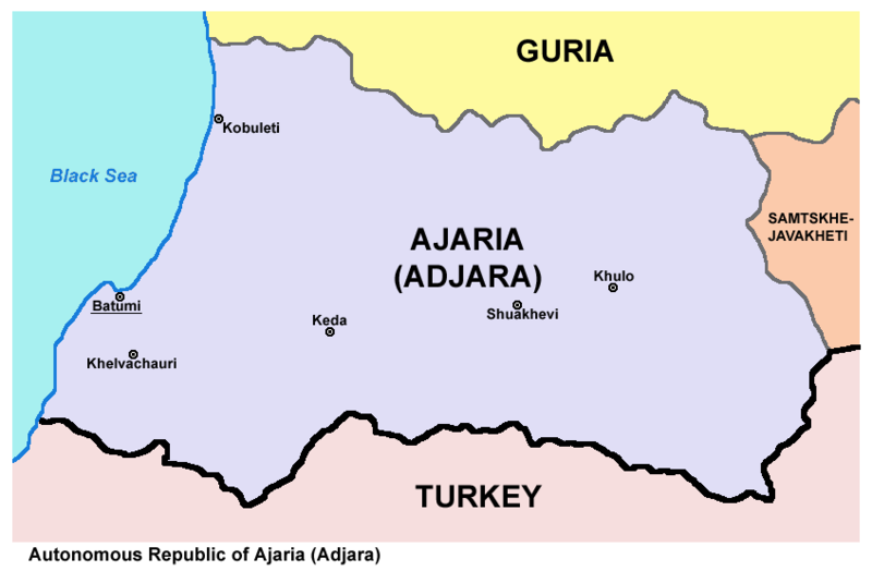
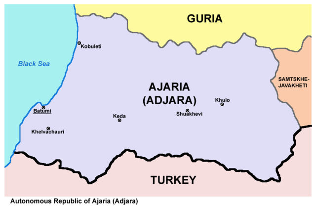
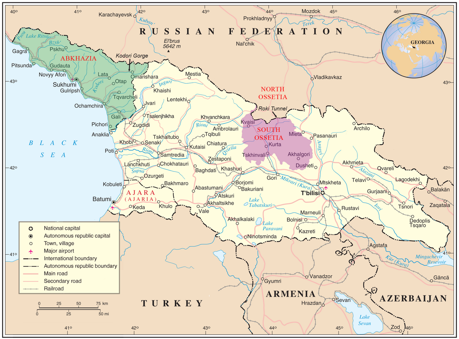
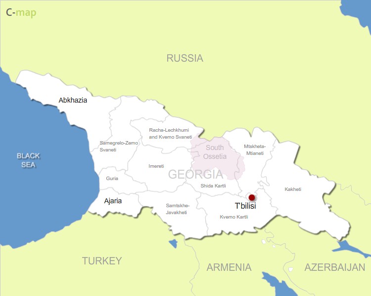
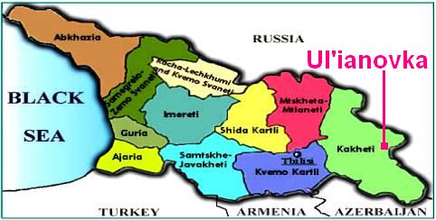
| Description | Map of Ajaria (Adjara) republic, Georgia. |
| Date | 19 December 2006 (original upload date) |
| Source | Own work |
| Author | PANONIAN |
Source and license
[edit]

|
This map has been uploaded by Electionworld from en.wikipedia.org to enable the |
self made map by PANONIAN
Licensing
[edit]
| I, the copyright holder of this work, release this work into the public domain. This applies worldwide. In some countries this may not be legally possible; if so: I grant anyone the right to use this work for any purpose, without any conditions, unless such conditions are required by law. |
References
[edit]
Maps from external links:
- http://maps.gol.ge/image/adjara.jpg archive copy at the Wayback Machine
- http://www.tour-hunting-georgia.ge/map_of_adjara.gif[dead link]
- http://www.magtifix.ge/upics/file/adjara.jpg archive copy at the Wayback Machine
- http://www.radiovan.fm/wp-content/uploads/2010/07/adjara.jpg archive copy at the Wayback Machine
- http://caucasustreasure.ge/images/news_images/2012-07/24/Adjara_caucasustreasure_1343115321.jpg[dead link]
- http://www.eurasianet.org/georgia/ajaria/images/ajaria_map2.jpg
- http://img.liveinternet.ru/images/attach/4/19108/19108451_Adjarya.jpg
- http://www.batumionline.net/travelbook/pics/maps/m_993.jpg
- http://karabakh-doc.azerall.info/ru/law/law031-6.jpg[dead link]
- http://www.penguinsix.com/images/ajaria.jpg
- http://media.web.britannica.com/eb-media/75/123975-004-271F20F5.gif archive copy at the Wayback Machine
- http://www.sublimeoblivion.com/wp-content/uploads/2008/08/georgia_map.jpg[dead link]
- http://4.bp.blogspot.com/-vfkp77CQCEk/T-78Md64MDI/AAAAAAAABs4/NsL6UJ9yzaY/s1600/adjara+map.png
- http://irakly.org/plugins/editors/xinha/plugins/ImageManager/demo_images/map_adjaria.gif
- http://www.ljplus.ru/img4/n/a/nashi_vrn/georgia_map_admin.jpg
- http://wikitravel.org/upload/shared/6/6a/Georgia_regions_map.png
- http://www.comersis.com/c-images/GE/Georgia-regions.jpg
- http://www.molokane.org/places/FSU/Georgia/Ulianovka/2009_Mar_15_TV/map_Georgia_regions.jpg
- http://www.encyclopedie-universelle.com/images/georgie-carte-regions.gif
- http://wikitravel.org/upload/shared/archive/c/cf/20080908160720!Georgia_regions_map2.png
File history
Click on a date/time to view the file as it appeared at that time.
| Date/Time | Thumbnail | Dimensions | User | Comment | |
|---|---|---|---|---|---|
| current | 17:32, 2 April 2021 | | 847 × 555 (30 KB) | Claude Zygiel (talk | contribs) | Differenciate shoreline, administrative boundaries in Georgia, and international boundary with Turkey |
| 11:31, 13 August 2012 |  | 847 × 555 (34 KB) | PANONIAN (talk | contribs) | improved my own work | |
| 22:51, 19 December 2006 |  | 477 × 297 (9 KB) | Electionworld (talk | contribs) | {{ew|en|PANONIAN}} map of Ajaria (self made) {{PD-self}} Category:Maps of Georgia |
You cannot overwrite this file.
File usage on Commons
The following 2 pages use this file:
File usage on other wikis
The following other wikis use this file:
- Usage on ab.wikipedia.org
- Usage on az.wikipedia.org
- Usage on be.wikipedia.org
- Usage on cs.wikipedia.org
- Usage on cv.wikipedia.org
- Usage on el.wikipedia.org
- Usage on eo.wikipedia.org
- Usage on et.wikipedia.org
- Usage on fi.wikipedia.org
- Usage on fr.wikipedia.org
- Usage on jv.wikipedia.org
- Usage on ko.wikipedia.org
- Usage on lt.wikipedia.org
- Usage on mk.wikipedia.org
- Usage on nn.wikipedia.org
- Usage on os.wikipedia.org
- Usage on pnb.wikipedia.org
- Usage on ro.wikipedia.org
- Usage on rw.wikipedia.org
- Usage on scn.wikipedia.org
- Usage on sh.wikipedia.org
- Usage on sq.wikipedia.org
- Usage on sr.wikipedia.org
- Usage on sv.wikipedia.org
- Usage on vo.wikipedia.org
- Usage on war.wikipedia.org