File:Taiwan ROC political divisions labeled.svg
Jump to navigation
Jump to search

Size of this PNG preview of this SVG file: 425 × 600 pixels. Other resolutions: 170 × 240 pixels | 340 × 480 pixels | 544 × 768 pixels | 725 × 1,024 pixels | 1,451 × 2,048 pixels | 850 × 1,200 pixels.
Original file (SVG file, nominally 850 × 1,200 pixels, file size: 343 KB)
Captions
Captions
Add a one-line explanation of what this file represents
| Description |
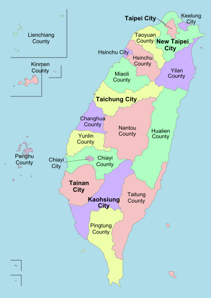
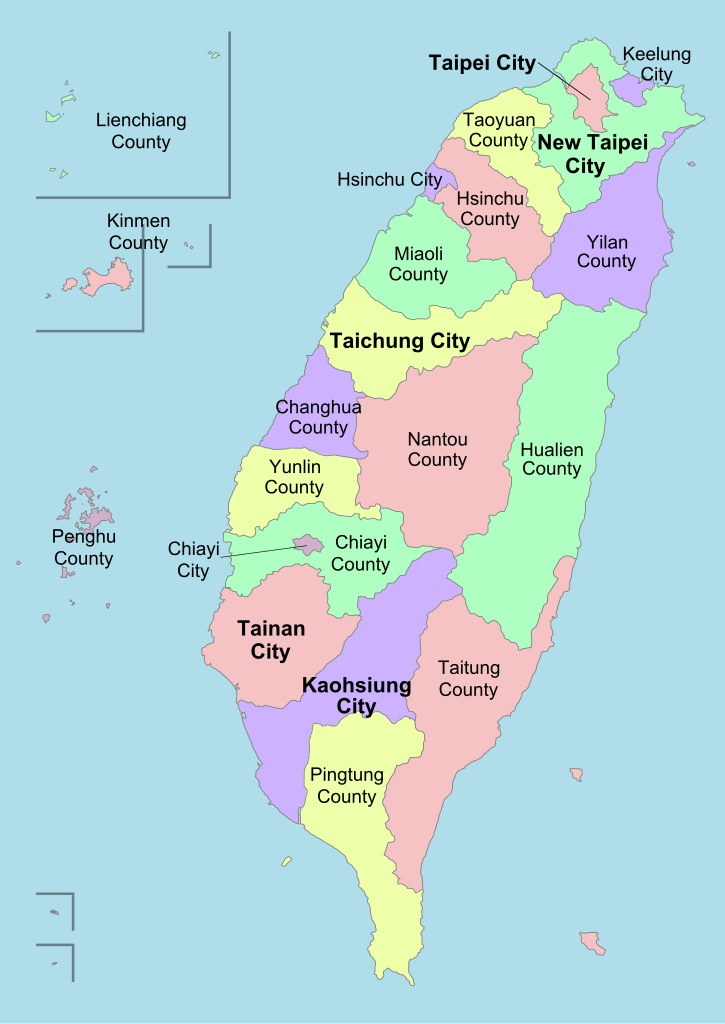
English: A political division map of Taiwan, ROC. |
| Date | (UTC) |
| Source | |
| Author |
|
| Other versions | Derivative works of this file: Taiwan ROC political divisions labeled-ar.png |
| This is a retouched picture, which means that it has been digitally altered from its original version. Modifications: Labels. The original can be viewed here: Taiwan ROC political division map.svg:
|
I, the copyright holder of this work, hereby publish it under the following licenses:
This file is licensed under the Creative Commons Attribution-Share Alike 3.0 Unported license.
- You are free:
- to share – to copy, distribute and transmit the work
- to remix – to adapt the work
- Under the following conditions:
- attribution – You must give appropriate credit, provide a link to the license, and indicate if changes were made. You may do so in any reasonable manner, but not in any way that suggests the licensor endorses you or your use.
- share alike – If you remix, transform, or build upon the material, you must distribute your contributions under the same or compatible license as the original.

|
Permission is granted to copy, distribute and/or modify this document under the terms of the GNU Free Documentation License, Version 1.2 or any later version published by the Free Software Foundation; with no Invariant Sections, no Front-Cover Texts, and no Back-Cover Texts. A copy of the license is included in the section entitled GNU Free Documentation License. |
You may select the license of your choice.
Original upload log[edit]
This image is a derivative work of the following images:
- File:Taiwan_ROC_political_division_map.svg licensed with Cc-by-sa-3.0, GFDL
- 2008-08-02T18:04:11Z Luuva 850x1200 (165850 Bytes) {{Information |Description= |Source= |Date= |Author= |Permission= |other_versions={{DerivativeVersions|Taiwan ROC political divisions labeled-ar.png}} }}
- 2008-07-28T18:10:28Z Luuva 850x1200 (412965 Bytes) {{Information |Description= |Source= |Date= |Author= |Permission= |other_versions={{DerivativeVersions|Taiwan ROC political divisions labeled-ar.png}} }}
- 2008-07-26T22:03:59Z Luuva 850x1200 (403644 Bytes) {{Information |Description= |Source= |Date= |Author= |Permission= |other_versions={{DerivativeVersions|Taiwan ROC political divisions labeled-ar.png}} }}
- 2008-07-26T19:35:07Z Luuva 850x1200 (947187 Bytes) {{Information |Description= |Source= |Date= |Author= |Permission= |other_versions={{DerivativeVersions|Taiwan ROC political divisions labeled-ar.png}} }}
- 2008-07-26T19:29:40Z Luuva 850x1200 (942999 Bytes) {{Information |Description= |Source= |Date= |Author= |Permission= |other_versions={{DerivativeVersions|Taiwan ROC political divisions labeled-ar.png}} }}
- 2008-07-26T12:44:12Z Luuva 850x1200 (444811 Bytes) {{Information |Description= |Source= |Date= |Author= |Permission= |other_versions={{DerivativeVersions|Taiwan ROC political divisions labeled-ar.png}} }}
- 2008-07-26T12:41:58Z Luuva 850x1200 (444803 Bytes) {{Information |Description= |Source= |Date= |Author= |Permission= |other_versions={{DerivativeVersions|Taiwan ROC political divisions labeled-ar.png}} }}
- 2008-07-26T12:38:59Z Luuva 850x1200 (444770 Bytes) {{Information |Description={{en|1=A political division map of Taiwan, ROC.}} |Source=Own work by uploader |Author=[[User:Luuva|Luuva]] |Date=July 2008 |Permission= |other_versions={{DerivativeVersions|Taiwan ROC political divisions labeled-ar.png}} }} [[Category:SVG maps
Uploaded with derivativeFX
File history
Click on a date/time to view the file as it appeared at that time.
| Date/Time | Thumbnail | Dimensions | User | Comment | |
|---|---|---|---|---|---|
| current | 22:39, 27 January 2013 | | 850 × 1,200 (343 KB) | AHCCCP (talk | contribs) | Reverted to version as of 00:06, 22 September 2011 |
| 16:54, 1 April 2012 |  | 850 × 1,200 (125 KB) | Kanguole (talk | contribs) | labels as text | |
| 00:06, 22 September 2011 |  | 850 × 1,200 (343 KB) | Energiya (talk | contribs) | New style, minor change | |
| 10:50, 17 August 2011 |  | 850 × 1,200 (124 KB) | Energiya (talk | contribs) | minor corrections | |
| 06:00, 4 January 2011 |  | 850 × 1,200 (117 KB) | Energiya (talk | contribs) | 2010 Administrative division reform | |
| 19:26, 11 April 2009 |  | 850 × 1,200 (157 KB) | Ran (talk | contribs) | bigger labels | |
| 19:16, 11 April 2009 |  | 850 × 1,200 (156 KB) | Ran (talk | contribs) | {{Information |Description={{en|1=A political division map of Taiwan, ROC.}} |Source=*File:Taiwan_ROC_political_division_map.svg |Date=2009-04-11 20:15 (UTC) |Author=*File:Taiwan_ROC_political_division_map.svg: Luuva *derivative |
You cannot overwrite this file.
File usage on Commons
The following 3 pages use this file:
File usage on other wikis
The following other wikis use this file:
- Usage on en.wikipedia.org
- Usage on fi.wikipedia.org
- Usage on fr.wiktionary.org
- Usage on he.wikipedia.org
- Usage on hu.wikipedia.org
- Usage on hy.wikipedia.org
- Usage on ko.wikipedia.org
- Usage on lv.wikipedia.org
- Usage on ml.wikipedia.org
- Usage on my.wikipedia.org
- Usage on pl.wikipedia.org
- Usage on pt.wikipedia.org
- Usage on simple.wikipedia.org
- Usage on tr.wikipedia.org
- Taipei
- Penghu Adaları
- Tainan
- Şablon:Tayvan'ın özel şehirleri, ilçeleri ve il şehirleri
- Yeni Taipei
- Kaohsiung
- Tayçung
- Hsinchu
- Keelung
- Taoyuan, Tayvan
- Chiayi
- Changhua (ilçe)
- Tayvan'ın idari bölümleri
- Chiayi (ilçe)
- Hsinchu (ilçe)
- Hualien (ilçe)
- Miaoli (ilçe)
- Nantou (ilçe)
- Pingtung (ilçe)
- Taitung (ilçe)
- Yunlin (ilçe)
View more global usage of this file.