File:Gutiérrez, the Americas, 1562.jpg
Jump to navigation
Jump to search

Size of this preview: 611 × 600 pixels. Other resolutions: 245 × 240 pixels | 489 × 480 pixels | 783 × 768 pixels | 1,044 × 1,024 pixels | 2,087 × 2,048 pixels | 5,246 × 5,148 pixels.
Original file (5,246 × 5,148 pixels, file size: 16.62 MB, MIME type: image/jpeg)
Captions
Captions
Add a one-line explanation of what this file represents
|
Summary[edit]
| Description |
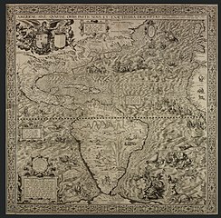
English: Map by Diego Gutiérrez showing the Spanish Empire at its height. Made for the approval of Philip II, here shown in the guise of Neptune – a relatively small figure in a seahorse-drawn chariot that is west of Florida. |
| Date | |
| Source | http://www.bl.uk/magnificentmaps/map3.html |
| Author | Diego Gutiérrez |
| Other versions |
 |
Licensing[edit]
|
This work is in the public domain in its country of origin and other countries and areas where the copyright term is the author's life plus 100 years or fewer. | |
| This file has been identified as being free of known restrictions under copyright law, including all related and neighboring rights. | |
| Annotations | This image is annotated: View the annotations at Commons |
File history
Click on a date/time to view the file as it appeared at that time.
| Date/Time | Thumbnail | Dimensions | User | Comment | |
|---|---|---|---|---|---|
| current | 03:31, 6 May 2010 | | 5,246 × 5,148 (16.62 MB) | Mturtle (talk | contribs) | {{Information |Description={{en|1=Shows the Spanish Empire at its height. Made for the approval of Philip II, here shown in the guise of Neptune}} |Source=http://www.bl.uk/magnificentmaps/map3.html |Author=Diego Gutiérrez |Date=1562 |Permission= |other_v |
You cannot overwrite this file.
File usage on Commons
The following 4 pages use this file:
File usage on other wikis
The following other wikis use this file:
- Usage on ar.wikipedia.org
- Usage on el.wikipedia.org
- Usage on en.wikipedia.org
- Age of Discovery
- Wikipedia:Featured pictures/Diagrams, drawings, and maps/Maps
- Iberian cartography, 1400–1600
- User:Peter Mercator/Map gallery
- Mercator 1569 world map
- Wikipedia:Featured pictures thumbs/40
- Wikipedia:Featured picture candidates/March-2014
- Americae Sive Quartae Orbis Partis Nova Et Exactissima Descriptio
- Talk:Americae Sive Quartae Orbis Partis Nova Et Exactissima Descriptio
- Wikipedia:Featured picture candidates/Americae Sive Quartae Orbis Partis Nova Et Exactissima Descriptio
- Wikipedia:Wikipedia Signpost/2014-04-02/Featured content
- Wikipedia:Wikipedia Signpost/Single/2014-04-02
- User talk:Brandmeister/Archive 10
- Wikipedia:Picture of the day/April 2016
- Template:POTD/2016-04-27
- Wikipedia:Main Page history/2016 April 27
- User talk:Brandmeister/Archive 12
- Portal:Geography/Selected picture
- Usage on es.wikipedia.org
- Usage on fr.wikipedia.org
- Usage on hy.wikipedia.org
- Usage on it.wikipedia.org
- Usage on ms.wikipedia.org
- Usage on ru.wikipedia.org
- Usage on sl.wikipedia.org
- Usage on test.wikipedia.org
- Usage on uk.wikipedia.org
- Usage on www.wikidata.org
- Usage on zh.wikipedia.org