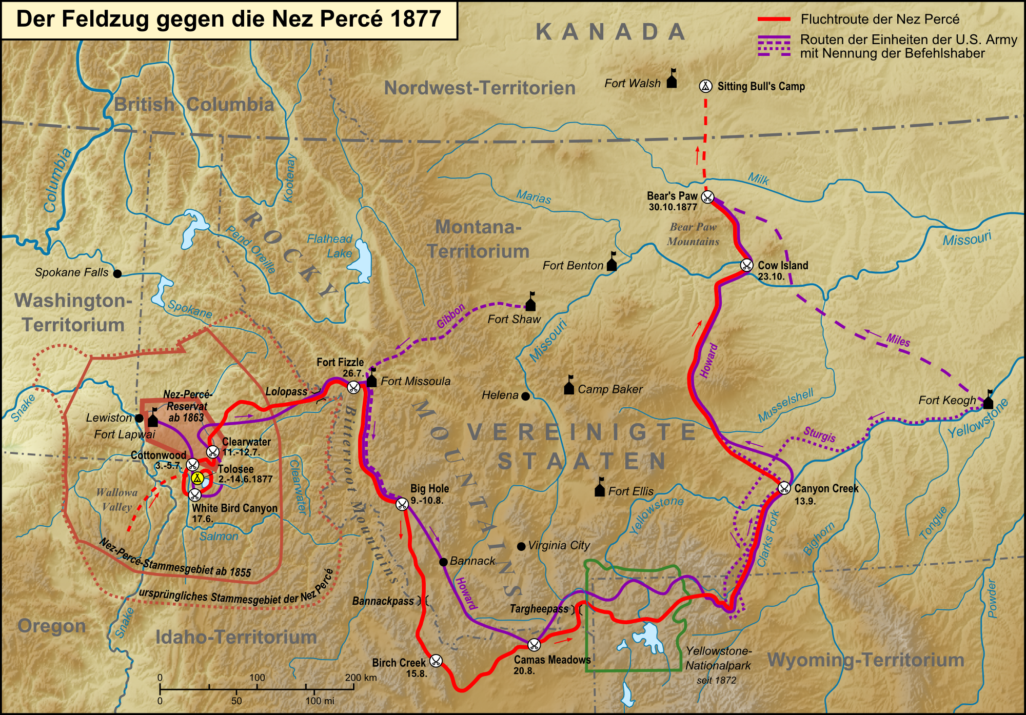
File:Feldzug gegen die Nez Perce 1877.png
Jump to navigation
Jump to search
Size of this preview: 800 × 558 pixels. Other resolutions: 320 × 223 pixels | 640 × 446 pixels | 1,024 × 714 pixels | 1,280 × 892 pixels | 2,000 × 1,394 pixels.
Original file (2,000 × 1,394 pixels, file size: 3.7 MB, MIME type: image/png)
Captions
Captions
Add a one-line explanation of what this file represents
This image has been assessed using the Quality image guidelines and is considered a Quality image.
|
Summary[edit]
| Description |
Deutsch: Karte des Feldzugs gegen die Nez Percé 1877 |
| Date | |
| Source |
Own work, used:
|
| Author | Lencer |
| Other versions |
|


|
This map has been made or improved in the German Kartenwerkstatt (Map Lab). You can propose maps to improve as well.
|
Licensing[edit]
The map has been created with the Generic Mapping Tools: https://www.generic-mapping-tools.org/ using one or more of these public-domain datasets for the relief:
|

|
Permission is granted to copy, distribute and/or modify this document under the terms of the GNU Free Documentation License, Version 1.2 or any later version published by the Free Software Foundation; with no Invariant Sections, no Front-Cover Texts, and no Back-Cover Texts. A copy of the license is included in the section entitled GNU Free Documentation License. |
File history
Click on a date/time to view the file as it appeared at that time.
| Date/Time | Thumbnail | Dimensions | User | Comment | |
|---|---|---|---|---|---|
| current | 12:26, 8 July 2014 | | 2,000 × 1,394 (3.7 MB) | Lencer (talk | contribs) | small fixes |
| 01:59, 12 March 2014 |  | 2,000 × 1,394 (3.28 MB) | Kopiersperre (talk | contribs) | optipng | |
| 12:27, 18 September 2011 |  | 2,000 × 1,394 (3.69 MB) | Lencer (talk | contribs) | small fixes | |
| 19:18, 16 September 2011 |  | 2,000 × 1,394 (3.69 MB) | Lencer (talk | contribs) | some fixes | |
| 18:49, 16 September 2011 |  | 2,000 × 1,394 (3.69 MB) | Lencer (talk | contribs) | + Legende, Maßstab, diverse Farbänderungen, Flussystem angepasst, zahlreiche Beschriftungen | |
| 20:01, 15 September 2011 |  | 2,000 × 1,303 (3.52 MB) | Lencer (talk | contribs) | {{Information| |Description=Karte des Feldzugs gegen die Nez Percé 1877 |Source=own work, used: * Generic Mapping Tools and SRTM3 V2-files for relief |Date=2011-09 |Author=[[User:Lencer|L |
You cannot overwrite this file.
File usage on Commons
The following 6 pages use this file:
File usage on other wikis
The following other wikis use this file:
- Usage on als.wikipedia.org
- Usage on de.wikipedia.org