File:Deutschland Landschaften.png
Jump to navigation
Jump to search

Size of this preview: 469 × 599 pixels. Other resolutions: 188 × 240 pixels | 376 × 480 pixels | 601 × 768 pixels | 801 × 1,024 pixels | 2,267 × 2,896 pixels.
Original file (2,267 × 2,896 pixels, file size: 10.64 MB, MIME type: image/png)
Captions
Captions
Add a one-line explanation of what this file represents
Summary[edit]
| Description |
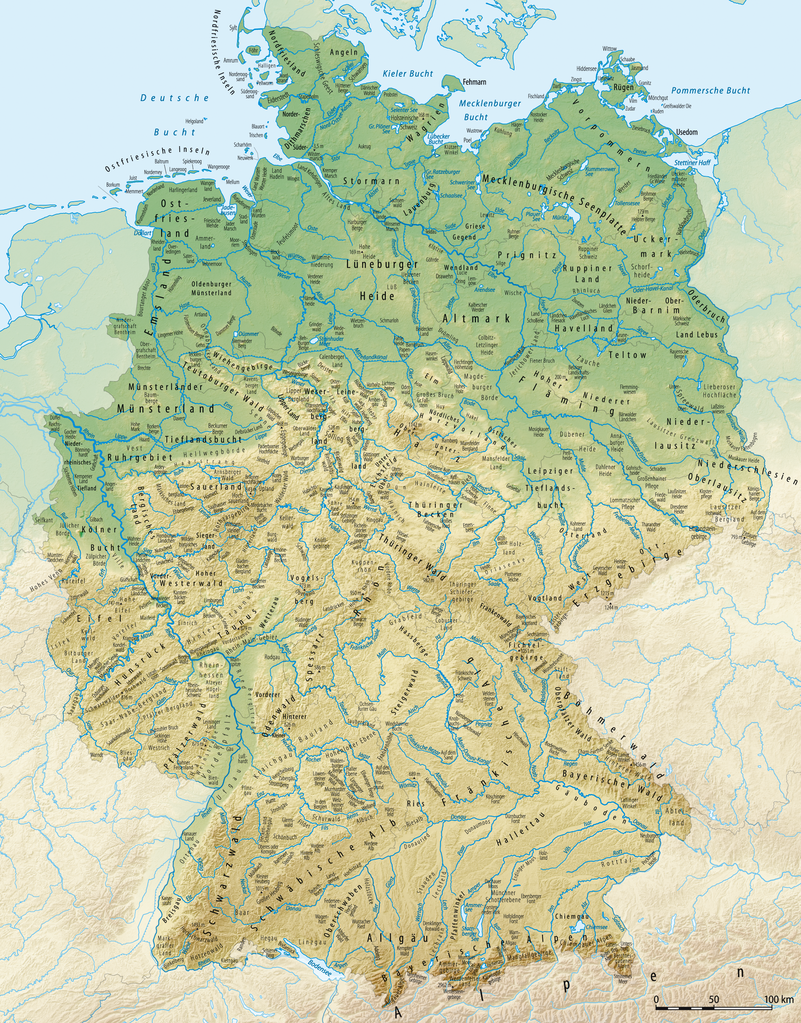
Deutsch: Karte der Landschaften von Deutschland
Die Karte enthält die Namen von Landschaften, großen Mooren und Wäldern. Gebiete, die zu klein sind, um sie angemessen beschriften zu können, wurden nicht in die Karte aufgenommen. Ebenfalls nicht aufgenommen wurden Landschaftsbezeichnung, die mit heutigen Verwaltungsgrenzen zusammenfallen (z.B. Oberpfalz oder Unterfranken), ortsnamengebundene Landschaftsteile (z.B. Eichstätter Alb) oder neue Landschaftsnamen, die aus touristischen Gründen geschaffen worden sind (z.B. Lausitzer Seenplatte oder Waldhessen) English: Map of the landscapes of Germany
Français : Carte des paysages de l’Allemagne |
| Date | |
| Source |
self-made, using
|
| Author | NordNordWest, shading by Lencer |
| Other versions |
Derivative works of this file: |

|
This map has been made or improved in the German Kartenwerkstatt (Map Lab). You can propose maps to improve as well.
|
Licensing[edit]
I, the copyright holder of this work, hereby publish it under the following licenses:

|
Permission is granted to copy, distribute and/or modify this document under the terms of the GNU Free Documentation License, Version 1.2 or any later version published by the Free Software Foundation; with no Invariant Sections, no Front-Cover Texts, and no Back-Cover Texts. A copy of the license is included in the section entitled GNU Free Documentation License. |
This file is licensed under the Creative Commons Attribution-Share Alike 3.0 Unported license.
- You are free:
- to share – to copy, distribute and transmit the work
- to remix – to adapt the work
- Under the following conditions:
- attribution – You must give appropriate credit, provide a link to the license, and indicate if changes were made. You may do so in any reasonable manner, but not in any way that suggests the licensor endorses you or your use.
- share alike – If you remix, transform, or build upon the material, you must distribute your contributions under the same or compatible license as the original.
You may select the license of your choice.
File history
Click on a date/time to view the file as it appeared at that time.
| Date/Time | Thumbnail | Dimensions | User | Comment | |
|---|---|---|---|---|---|
| current | 13:25, 8 October 2015 | | 2,267 × 2,896 (10.64 MB) | NordNordWest (talk | contribs) | corr |
| 17:57, 29 April 2010 |  | 2,282 × 2,896 (8.29 MB) | NordNordWest (talk | contribs) | korrigiert und ergänzt | |
| 20:19, 16 February 2010 |  | 2,283 × 2,898 (8.36 MB) | NordNordWest (talk | contribs) | update | |
| 17:06, 23 June 2008 |  | 2,283 × 2,898 (8.4 MB) | NordNordWest (talk | contribs) | ||
| 17:31, 19 June 2008 |  | 2,283 × 2,898 (8.37 MB) | NordNordWest (talk | contribs) | ||
| 18:46, 18 June 2008 |  | 1,979 × 2,322 (5.65 MB) | NordNordWest (talk | contribs) | {{Information |Description= {{de|Karte der wichtigsten Gebirge und Landschaften von Deutschland}} {{en|Map of the most important mountains and landscapes of Germany}} |Source=self-made, using * [[:de:Generic Mapping Too |
You cannot overwrite this file.
File usage on Commons
The following 5 pages use this file:
File usage on other wikis
The following other wikis use this file:
- Usage on als.wikipedia.org
- Usage on ar.wikipedia.org
- Usage on bg.wikipedia.org
- Usage on cs.wikipedia.org
- Usage on de.wikipedia.org
- Usage on hy.wikipedia.org
- Usage on id.wikipedia.org
- Usage on it.wikipedia.org
- Usage on ja.wikipedia.org
- Usage on ko.wikipedia.org
- Usage on pl.wikipedia.org
- Usage on rm.wikipedia.org
- Usage on ru.wikipedia.org
- Usage on sv.wikipedia.org
- Usage on www.wikidata.org