File:Cristo Rei posto administrativo.png
Jump to navigation
Jump to search
Size of this preview: 387 × 599 pixels. Other resolutions: 155 × 240 pixels | 310 × 480 pixels | 739 × 1,144 pixels.
Original file (739 × 1,144 pixels, file size: 301 KB, MIME type: image/png)
Captions
Captions
Add a one-line explanation of what this file represents
Summary[edit]
| Description |
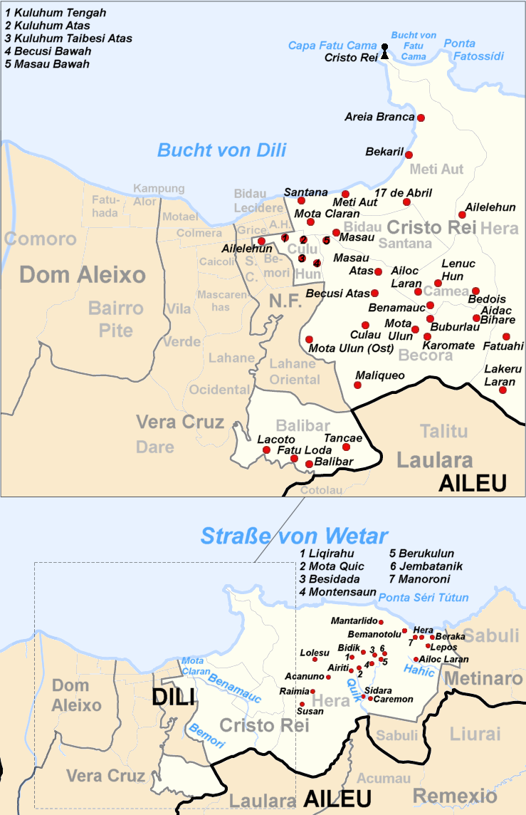
Deutsch: Verwaltungskarte des Verwaltungsamts Cristo Rei in Osttimor English: Administrative map of the Cristo Rei administrative post of East Timor |
| Date | (UTC) |
| Source |
This file was derived from: Administrative map of the Dilli district of East Timor.png:  |
| Author |
| This is a retouched picture, which means that it has been digitally altered from its original version. Modifications: create map of Cristo Rei subdistrict. The original can be viewed here: Administrative map of the Dilli district of East Timor.png:
|
Licensing[edit]
I, the copyright holder of this work, hereby publish it under the following license:
This file is licensed under the Creative Commons Attribution-Share Alike 2.5 Generic license.
- You are free:
- to share – to copy, distribute and transmit the work
- to remix – to adapt the work
- Under the following conditions:
- attribution – You must give appropriate credit, provide a link to the license, and indicate if changes were made. You may do so in any reasonable manner, but not in any way that suggests the licensor endorses you or your use.
- share alike – If you remix, transform, or build upon the material, you must distribute your contributions under the same or compatible license as the original.
Original upload log[edit]
This image is a derivative work of the following images:
- File:Administrative_map_of_the_Dilli_district_of_East_Timor.png licensed with Cc-by-sa-2.5
- 2012-08-08T20:10:32Z NordNordWest 1441x1928 (133925 Bytes) upd
- 2009-09-22T05:17:49Z Chumwa 1441x1928 (185415 Bytes) Ausschnittvergrößreung von Dilli hinzugefügt
- 2009-09-19T06:07:46Z Chumwa 1441x1928 (135878 Bytes) {{Information |Description= {{ de }} Verwaltungskarte des Distrikts Dilli in Osttimor {{ en }} Administrative map of the Dilli district of East Timor |Source=Self made, using informations from the[http://websig.civil.ist.utl.
Uploaded with derivativeFX
File history
Click on a date/time to view the file as it appeared at that time.
| Date/Time | Thumbnail | Dimensions | User | Comment | |
|---|---|---|---|---|---|
| current | 12:08, 18 February 2016 | | 739 × 1,144 (301 KB) | J. Patrick Fischer (talk | contribs) | correction One-Dollar-Beach |
| 21:38, 11 October 2015 |  | 739 × 1,144 (301 KB) | J. Patrick Fischer (talk | contribs) | One more cape | |
| 20:48, 11 October 2015 |  | 739 × 1,144 (298 KB) | J. Patrick Fischer (talk | contribs) | Correction http://seedsoflifetimor.org/wp-content/uploads/2013/01/ta004-Solos_5_Dilig.png | |
| 18:58, 7 December 2013 |  | 739 × 1,144 (295 KB) | J. Patrick Fischer (talk | contribs) | +Sidara | |
| 15:15, 17 February 2013 |  | 739 × 1,144 (288 KB) | J. Patrick Fischer (talk | contribs) | == {{int:filedesc}} == {{Information |Description={{ de }} Verwaltungskarte des Subdistrikts Cristo Rei in Osttimor {{ en }} Administrative map of the Cristo Rei subdistrict of East Timor |Source={{Derived from|Administrative_map_of_the_Dilli_district_... |
You cannot overwrite this file.
File usage on Commons
The following 3 pages use this file:
File usage on other wikis
The following other wikis use this file:
- Usage on ar.wikipedia.org
- Usage on de.wikipedia.org
- Usage on pt.wikipedia.org
- Usage on tet.wikipedia.org
- Usage on www.wikidata.org
- Usage on zh.wikipedia.org