File:Charon Chasm.jpg
Jump to navigation
Jump to search

Size of this preview: 800 × 511 pixels. Other resolutions: 320 × 204 pixels | 640 × 409 pixels | 1,024 × 654 pixels | 1,280 × 817 pixels | 2,378 × 1,518 pixels.
Original file (2,378 × 1,518 pixels, file size: 133 KB, MIME type: image/jpeg)
Captions
Captions
Add a one-line explanation of what this file represents
Summary[edit]
| Description |
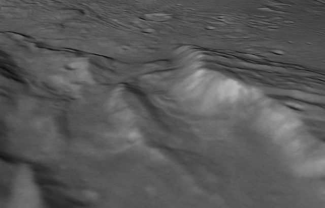
English: Scientists from NASA's New Horizons mission have spotted signs of long run-out landslides on Pluto's largest moon, Charon. This perspective view of Charon's informally named Serenity Chasm consists of topography generated from stereo reconstruction of images taken by New Horizons, Long Range Reconnaissance Imager (LORRI) and Multispectral Visible Imaging Camera (MVIC), supplemented by a "shape-from-shading" algorithm. The topography is then overlain with this image mosaic (link to first image) and the perspective view is rendered. The MVIC image was taken from a distance of 45,458 miles (73,159 kilometers) while the LORRI picture was taken from 19,511 miles (31,401 kilometers) away, both on July 14, 2015. |
| Date | |
| Source | http://pluto.jhuapl.edu/Multimedia/Science-Photos/image.php?page=1&gallery_id=2&image_id=468 |
| Author | NASA/Johns Hopkins University Applied Physics Laboratory/Southwest Research Institute |
Licensing[edit]
| This file is in the public domain in the United States because it was solely created by NASA. NASA copyright policy states that "NASA material is not protected by copyright unless noted". (See Template:PD-USGov, NASA copyright policy page or JPL Image Use Policy.) | ||
 |
Warnings:
|
File history
Click on a date/time to view the file as it appeared at that time.
| Date/Time | Thumbnail | Dimensions | User | Comment | |
|---|---|---|---|---|---|
| current | 10:08, 20 October 2016 | | 2,378 × 1,518 (133 KB) | PlanetUser (talk | contribs) | User created page with UploadWizard |
You cannot overwrite this file.
File usage on Commons
The following page uses this file: