File:1930 Map of the Republic of China.JPG

Original file (1,171 × 817 pixels, file size: 272 KB, MIME type: image/jpeg)
Captions
Captions
Summary[edit]
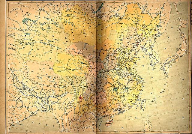
| Description |
English: The national map of the Republic of China in 1930. The copyright has expired due to the duration of the copyright is 50 years since publication pursuant to the laws of the People's Republic of China (Mainland) and the Republic of China (now Taiwan). Taiwan was still under Japanese rule at that time. |
| Date | Published in 1930, scanned in 2000s |
| Source | Own work |
| Author | Republic of China (ROC, now Taiwan) |
| Other versions |
.JPG)
This image is now in the public domain in China because its term of copyright has expired. According to copyright laws of the People's Republic of China (with legal jurisdiction in the mainland only, excluding Hong Kong and Macao), amended November 11, 2020, Works of legal persons or organizations without legal personality, or service works, or audiovisual works, enter the public domain 50 years after they were first published, or if unpublished 50 years from creation. For photography works of natural persons whose copyright protection period expires before June 1, 2021 belong to the public domain. All other works of natural persons enter the public domain 50 years after the death of the creator. To uploader: Please provide where the image was first published and who created it or held its copyright.
|
  |
Licensing[edit]
| I, the copyright holder of this work, release this work into the public domain. This applies worldwide. In some countries this may not be legally possible; if so: I grant anyone the right to use this work for any purpose, without any conditions, unless such conditions are required by law. |
File history
Click on a date/time to view the file as it appeared at that time.
| Date/Time | Thumbnail | Dimensions | User | Comment | |
|---|---|---|---|---|---|
| current | 20:38, 19 November 2009 | | 1,171 × 817 (272 KB) | 43tthsrxnj (talk | contribs) | {{Information |Description={{en|1=The national map of the Republic of China in 1930. The copyright has expired due to the duration of the copyright is 50 years since publication pursuant to the laws of the People's Republic of China (Mainland) and the Rep |
You cannot overwrite this file.
File usage on Commons
The following 2 pages use this file:
- 1930s maps of China
- Maps of the Republic of China (1912–1949)
- 1930 maps
- Xikang
- Old maps of Bhutan
- 20th-century maps of Nepal
- 20th-century maps of Tibet
- Qinghai Lake
- 20th-century maps of India
- Maps of the Brahmaputra
- Old maps of Myanmar
- Old maps of Taiwan
- Old maps of Mongolia
- Maps of East Turkestan
- 1930s maps of Japan
- 1930s maps of Korea
- Maps of Tibetan Plateau
- Chahar