File:Cape Helles landing map-tr.svg
Jump to navigation
Jump to search

Size of this PNG preview of this SVG file: 789 × 599 pixels. Other resolutions: 316 × 240 pixels | 632 × 480 pixels | 1,011 × 768 pixels | 1,280 × 972 pixels | 2,560 × 1,944 pixels | 1,052 × 799 pixels.
Original file (SVG file, nominally 1,052 × 799 pixels, file size: 158 KB)
Captions
Captions
Add a one-line explanation of what this file represents
Summary
[edit]| Description |
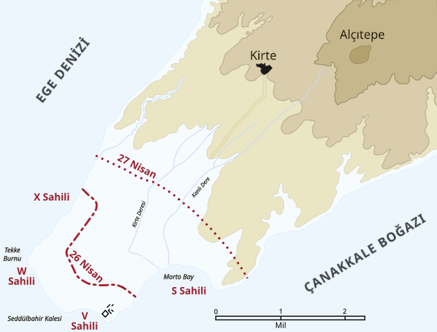
English: Map of the landing of the British 29th Division at Cape Helles on April 25, 1915 during the Battle of Gallipoli. The front line established by the night of April 26 is shown by the red dash-dot line. The front line reached by the night of April 27 is shown by the red dotted line. This became the "jumping off" line for the First Battle of Krithia. |
||
| Date | |||
| Source |
Self created from map [1] in Hamilton, Ian (1920) Gallipoli Diary, Volume I, Category:New York: George H Doran Company 2-)Cape Helles landing map.jpg |
||
| Author | SAİT71, Gsl | ||
| Permission (Reusing this file) |
|
||
| Other versions |
|


![[1]](http://gutenberg.readingroo.ms/1/9/3/1/19317/19317-h/images/img-map.jpg)
File history
Click on a date/time to view the file as it appeared at that time.
| Date/Time | Thumbnail | Dimensions | User | Comment | |
|---|---|---|---|---|---|
| current | 10:07, 11 August 2018 | | 1,052 × 799 (158 KB) | SAİT71 (talk | contribs) | User created page with UploadWizard |
You cannot overwrite this file.
File usage on Commons
The following 6 pages use this file:
File usage on other wikis
The following other wikis use this file:
- Usage on tr.wikipedia.org